

Size of this PNG preview of this SVG file: 486 × 599 pixels. Other resolutions: 195 × 240 pixels | 389 × 480 pixels | 623 × 768 pixels | 831 × 1,024 pixels | 1,662 × 2,048 pixels | 1,038 × 1,279 pixels.
Original file (SVG file, nominally 1,038 × 1,279 pixels, file size: 456 KB)
| This is a file from the Wikimedia Commons. Information from its description page there is shown below. Commons is a freely licensed media file repository. You can help. |
Summary
| Description |
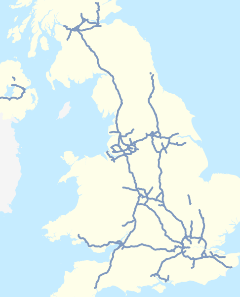
Map of the motorways of the United Kingdom in 2016 (including motorways under construction, not separately identified).
Equirectangular map projection on WGS 84 datum. |
| Date | |
| Source |
This file was derived from:
|
| Author |
|
| Other versions |
|


_svg)
.svg)
.svg)
References
Information about motorways under construction:
- Forth Replacement Crossing maps, Transport Scotland, accessed 2016-02-24
- M8 M73 M74 Improvements map, Transport Scotland, accessed 2016-02-24
- A1 Leeming to Barton Improvement archive copy at the Wayback Machine, Highways England, accessed 2016-02-24
Licensing
| This work contains information from OpenStreetMap, which is made available under the Open Database License (ODbL).
The ODbL does not require any particular license for maps produced from ODbL data. Prior to 1 August 2020, map tiles produced by the OpenStreetMap Foundation were licensed under the CC-BY-SA-2.0 license. Maps produced by other people may be subject to other licences. |
This file is licensed under the Creative Commons Attribution-Share Alike 4.0 International license.
Attribution: Nilfanion and Dr Greg. © OpenStreetMap contributors. Contains Ordnance Survey data © Crown copyright and database right 2010.
- You are free:
- to share – to copy, distribute and transmit the work
- to remix – to adapt the work
- Under the following conditions:
- attribution – You must give appropriate credit, provide a link to the license, and indicate if changes were made. You may do so in any reasonable manner, but not in any way that suggests the licensor endorses you or your use.
- share alike – If you remix, transform, or build upon the material, you must distribute your contributions under the same or compatible license as the original.
File history
Click on a date/time to view the file as it appeared at that time.
| Date/Time | Thumbnail | Dimensions | User | Comment | |
|---|---|---|---|---|---|
| current | 17:27, 25 February 2016 | | 1,038 × 1,279 (456 KB) | Dr Greg | User created page with UploadWizard |
File usage
More than 100 pages use this file. The following list shows the first 100 pages that use this file only. A full list is available.
.svg)
- A1(M) motorway
- A167 road
- A18 road (England)
- A194 road
- A308(M) motorway
- A329(M) motorway
- A38(M) motorway
- A3 road
- A404 road
- A41 road
- A48(M) motorway
- A601(M) motorway
- A6144(M) motorway
- A627(M) motorway
- A66 road
- A74(M) and M74 motorways
- A8(M) motorway (Northern Ireland)
- A823(M) motorway
- Almondsbury Interchange
- Broxden Junction
- Catthorpe Interchange
- Charing Cross, Glasgow
- Denton Island
- East Cross Route
- Leeds Inner Ring Road
- List of motorways in the United Kingdom
- List of roads and highways
- M10 motorway (Great Britain)
- M11 motorway
- M12 motorway
- M12 motorway (Great Britain)
- M15 motorway (Great Britain)
- M16 motorway
- M180 motorway
- M181 motorway
- M18 motorway (Great Britain)
- M1 motorway
- M1 motorway (Northern Ireland)
- M20 motorway
- M22 motorway (Northern Ireland)
- M23 motorway
- M25 motorway
- M26 motorway
- M271 motorway
- M275 motorway
- M27 motorway
- M2 motorway (Great Britain)
- M2 motorway (Northern Ireland)
- M31 motorway
- M32 motorway
- M3 motorway (Great Britain)
- M3 motorway (Northern Ireland)
- M40 motorway
- M42 motorway
- M45 motorway
- M48 motorway
- M49 motorway
- M4 bus lane
- M4 motorway
- M4 relief road
- M50 motorway (Great Britain)
- M53 motorway
- M54 motorway
- M55 motorway
- M56 motorway
- M57 motorway
- M58 motorway
- M5 motorway
- M5 motorway (Northern Ireland)
- M602 motorway
- M606 motorway
- M60 motorway (Great Britain)
- M61 motorway
- M621 motorway
- M62 motorway
- M63 motorway
- M64 motorway
- M65 motorway
- M66 motorway
- M67 motorway
- M69 motorway
- M6 Toll
- M6 motorway
- M73 motorway
- M77 motorway
- M80 motorway
- M876 motorway
- M898 motorway
- M8 motorway (Scotland)
- M90 motorway
- M9 motorway (Scotland)
- Mancunian Way
- National Highways
- National Highways traffic officer
- Scotch Corner
- Smart motorway
- Spaghetti Junction, Birmingham
- Switch Island
- West Cross Route
- Westway (London)
View more links to this file.
Global file usage
The following other wikis use this file:
- Usage on uk.wikipedia.org
- Другий Севернський міст
- Автомагістраль М1 (Велика Британія)
- Схема нумерації доріг Великої Британії
- Автомагістраль М2 (Велика Британія)
- Автомагістраль М3 (Велика Британія)
- Автомагістраль М4 (Велика Британія)
- Автомагістраль М5 (Велика Британія)
- Автомагістраль М8 (Велика Британія)
- Автомагістраль М9 (Велика Британія)
- Автомагістраль М11 (Велика Британія)
- Автомагістраль M18 (Велика Британія)
- Автомагістраль М20 (Велика Британія)
- Автомагістраль М25 (Велика Британія)
- Північна кільцева дорога (Велика Британія)
- Південна кільцева дорога (Велика Британія)
- Внутрішня кільцева дорога Лондона
- Шаблон:Автошляхи Великої Британії
- Автомагістраль М6 (Велика Британія)
- Автомагістраль М73 (Велика Британія)
- Автомагістраль М23 (Велика Британія)
- Автомагістраль М40 (Велика Британія)
- Автомагістраль М60 (Велика Британія)
- Автомагістраль М6 платна (Велика Британія)
- Автомагістраль М50 (Велика Британія)
- Автомагістраль М1 (Північна Ірландія)
- Автомагістраль М2 (Північна Ірландія)
- Автомагістраль A74(M) та M74 (Велика Британія)
- Автомагістраль М77 (Велика Британія)
- Автомагістраль М90 (Велика Британія)
- Автомагістраль М32 (Велика Британія)
- Usage on zh.wikipedia.org
.svg)