To install click the Add extension button. That's it.
The source code for the WIKI 2 extension is being checked by specialists of the Mozilla Foundation, Google, and Apple. You could also do it yourself at any point in time.
How to transfigure the Wikipedia
Would you like Wikipedia to always look as professional and up-to-date? We have created a browser extension. It will enhance any encyclopedic page you visit with the magic of the WIKI 2 technology.
Try it — you can delete it anytime.
Install in 5 seconds
Yep, but later
4,5
Kelly Slayton
Congratulations on this excellent venture… what a great idea!
Alexander Grigorievskiy
I use WIKI 2 every day and almost forgot how the original Wikipedia looks like.
Live Statistics
English Articles
Improved in 24 Hours
Added in 24 Hours
What we do. Every page goes through several hundred of perfecting techniques; in live mode. Quite the same Wikipedia. Just better.
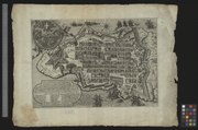
This image is from the collection of the Basel University Library and has been published on Wikimedia Commons as part of a cooperation with Wikimedia CH. Corrections and additional information are welcome.
Public domainPublic domainfalsefalse
This work is in the public domain in its country of origin and other countries and areas where the copyright term is the author's life plus 100 years or fewer.
https://creativecommons.org/publicdomain/mark/1.0/PDMCreative Commons Public Domain Mark 1.0falsefalse
The document is in the public domain. It may be used without restrictions. The Basel University Library recommends that the name of the source of the original document is mentioned when the document is used.
Recommended forms of attribution: English: Basel University Library, Kartenslg Mappe 97:40c German: Universitätsbibliothek Basel, Kartenslg Mappe 97:40c French: Bibliothèque publique et universitaire de Bâle-Ville, Kartenslg Mappe 97:40cPublic domainPublic domainfalsefalse
In Roma appresso Mattieo Perez de Allecio / Südostorientiert / Wappenkartusche oben links, Kartusche mit Erläuterungen und Legende unten links, Massstab rechts


_De_belegering_van_Malta_(serietitel),_RP-P-1911-3651.jpg)
_published_in_the_1588_Statutes_of_the_Order_of_Malta_published_in_Rome_by_Tito_and_Paolo_Diani.jpg)
