

Size of this PNG preview of this SVG file: 800 × 552 pixels. Other resolutions: 320 × 221 pixels | 640 × 442 pixels | 1,024 × 707 pixels | 1,280 × 884 pixels | 2,560 × 1,767 pixels | 1,424 × 983 pixels.
Original file (SVG file, nominally 1,424 × 983 pixels, file size: 189 KB)
| This is a file from the Wikimedia Commons. Information from its description page there is shown below. Commons is a freely licensed media file repository. You can help. |
Summary
| Description |
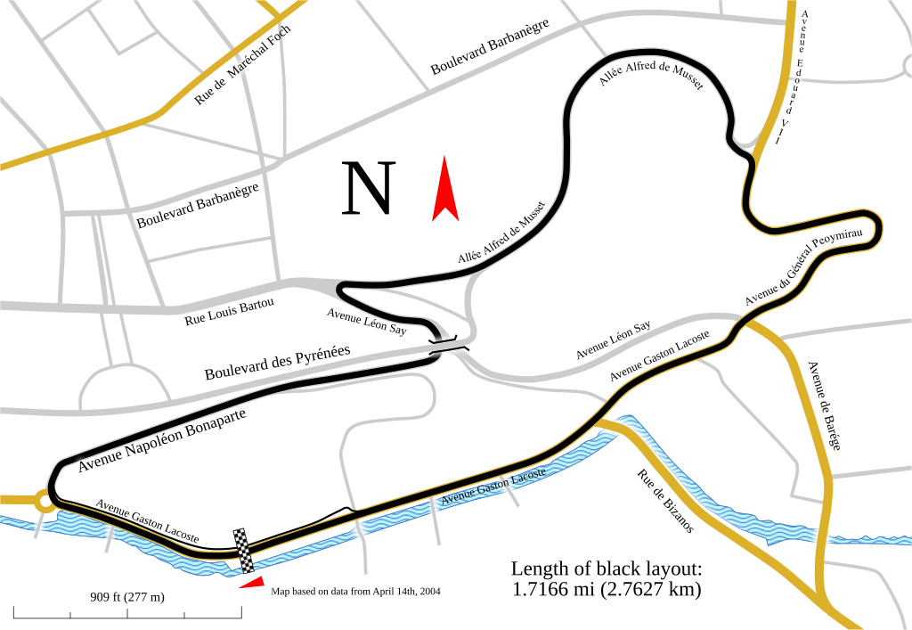
Track map for use with Pau Grand Prix. This version shows the track as it was in 2007.
Notes:
|
| Date | |
| Source | Own work |
| Author | Will Pittenger |
| Other versions |
Older images by other authors for the same track
Same map, but with different data
|

![]]](http://commons.wikimedia.org/wiki/File:Track_map_for_the_Pau_street_circuit_--_2007.svg)
This W3C-unspecified vector image was created with Inkscape .
| Camera location | | View this and other nearby images on: OpenStreetMap |
|---|
Licensing
I, the copyright holder of this work, hereby publish it under the following license:
This file is licensed under the Creative Commons Attribution-Share Alike 3.0 Unported license.
- You are free:
- to share – to copy, distribute and transmit the work
- to remix – to adapt the work
- Under the following conditions:
- attribution – You must give appropriate credit, provide a link to the license, and indicate if changes were made. You may do so in any reasonable manner, but not in any way that suggests the licensor endorses you or your use.
- share alike – If you remix, transform, or build upon the material, you must distribute your contributions under the same or compatible license as the original.
File history
Click on a date/time to view the file as it appeared at that time.
| Date/Time | Thumbnail | Dimensions | User | Comment | |
|---|---|---|---|---|---|
| current | 03:29, 12 February 2010 | | 1,424 × 983 (189 KB) | Will Pittenger | The version being reverted is for editing purposes. This version is the viewable verison |
| 03:28, 12 February 2010 |  | 1,424 × 983 (121 KB) | Will Pittenger | One of these days... | |
| 03:26, 12 February 2010 |  | 1,424 × 983 (189 KB) | Will Pittenger | Oops. Previous version already had the text on path objects converted into paths. Since a version online is needed that is editable, I have to upload this version. | |
| 03:22, 12 February 2010 |  | 1,424 × 983 (189 KB) | Will Pittenger | Found out that pit lane was actually in a different spot and moved it to the correct location. Note: Three text objects are now on paths. This version is for editing only. | |
| 21:06, 6 February 2010 |  | 1,424 × 983 (287 KB) | Will Pittenger | The text objects that were on paths are now plain paths. If you need to edit this file, please follow the instructions in the description. | |
| 21:00, 6 February 2010 |  | 1,424 × 983 (120 KB) | Will Pittenger | {{Information |Description={{en|1=Track map for use with w:Pau Grand Prix. This version shows the track as it was in w:2007. Notes: *This map has three text objects on paths. MediaWiki/RSVG has a bug causing it to hide all such objects. Henc |
File usage
The following pages on the English Wikipedia use this file (pages on other projects are not listed):
Global file usage
The following other wikis use this file:
- Usage on ast.wikipedia.org
- Usage on cs.wikipedia.org
- Usage on de.wikipedia.org
- Usage on es.wikipedia.org
- Usage on fi.wikipedia.org
- Usage on hu.wikipedia.org
- Usage on it.wikipedia.org
- Usage on ja.wikipedia.org
- Usage on nl.wikipedia.org
- Usage on no.wikipedia.org
- Usage on pt.wikipedia.org
- Usage on ru.wikipedia.org
- Usage on sl.wikipedia.org
- Usage on www.wikidata.org