
_-_geograph.org.uk_-_766525_jpg)
No higher resolution available.
The_start_of_the_A601(M)_-_geograph.org.uk_-_766525.jpg (640 × 426 pixels, file size: 63 KB, MIME type: image/jpeg)
| This is a file from the Wikimedia Commons. Information from its description page there is shown below. Commons is a freely licensed media file repository. You can help. |
_-_geograph.org.uk_-_766525.jpg)
Summary
| Description |
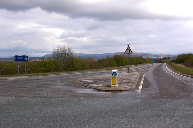
The start of the A601(M) The A601(M) has two parts - the part west of Junction 35 with the M6 is a dual carriageway link to the A6, and once formed the northern end of the M6 until the main motorway was extended northwards. But the eastern part was added in 1987 to enable lorries from the quarries to the south to join the M6 without having to go through Carnforth. Its potential usage didn't justify a full blown dual carriageway, but because it gave nowhere to go for non-motorway traffic, it had to be designated a motorway. The result: a stretch of single carriageway motorway, with two way traffic, which ends at a T junction with a B road (the B6254), as shown here! Note the motorway and two way traffic signs.
Not as impressive in length as what was the A6144(M) in Greater Manchester (SJ7793), which is also single carriageway but alas is now no longer a motorway, despite what the map for the square still shows (and unfortunately there are no photos of it on Geograph), but the A601(M) is still a worthy feature of the UK road network. In particular, being a motorway without speed limit indications, it presumably has a 70mph speed limit - one of the few places in the country where one can legally travel at 70mph on a non-dual carriageway, not that the stretch of road is really long enough to allow it! |
| Date | |
| Source | From geograph.org.uk |
| Author | Ian Capper |
| Attribution (required by the license) | Ian Capper / The start of the A601(M) / |
| Camera location | | View this and other nearby images on: OpenStreetMap |
|---|
_-_geograph.org.uk_-_766525.jpg¶ms=054.123730_N_-002.753000_E_globe:Earth_type:camera_source:geograph-osgb36(SD50887002)_heading:45.00&language=en)
| Object location | | View this and other nearby images on: OpenStreetMap |
|---|
_-_geograph.org.uk_-_766525.jpg¶ms=054.124090_N_-002.752500_E_globe:Earth_class:object_type:object_source:geograph-osgb36(SD50917006)_heading:45.00&language=en)
Licensing

|
This image was taken from the Geograph project collection. See this photograph's page on the Geograph website for the photographer's contact details. The copyright on this image is owned by Ian Capper and is licensed for reuse under the Creative Commons Attribution-ShareAlike 2.0 license.
|
This file is licensed under the Creative Commons Attribution-Share Alike 2.0 Generic license.
Attribution: Ian Capper
- You are free:
- to share – to copy, distribute and transmit the work
- to remix – to adapt the work
- Under the following conditions:
- attribution – You must give appropriate credit, provide a link to the license, and indicate if changes were made. You may do so in any reasonable manner, but not in any way that suggests the licensor endorses you or your use.
- share alike – If you remix, transform, or build upon the material, you must distribute your contributions under the same or compatible license as the original.
File history
Click on a date/time to view the file as it appeared at that time.
| Date/Time | Thumbnail | Dimensions | User | Comment | |
|---|---|---|---|---|---|
| current | 19:58, 19 February 2011 | | 640 × 426 (63 KB) | GeographBot | == {{int:filedesc}} == {{Information |description={{en|1=The start of the A601(M) The A601(M) has two parts - the part west of Junction 35 with the M6 is a dual carriageway link to the A6, and once formed the northern end of the M6 until the main motorway |
File usage
The following pages on the English Wikipedia use this file (pages on other projects are not listed):
Global file usage
The following other wikis use this file:
- Usage on pl.wikipedia.org
- Usage on www.wikidata.org
_-_geograph.org.uk_-_766525.jpg)