
No higher resolution available.
The_Festival_Inn_-_geograph.org.uk_-_864149.jpg (640 × 474 pixels, file size: 92 KB, MIME type: image/jpeg)
| This is a file from the Wikimedia Commons. Information from its description page there is shown below. Commons is a freely licensed media file repository. You can help. |
Summary
| Description |
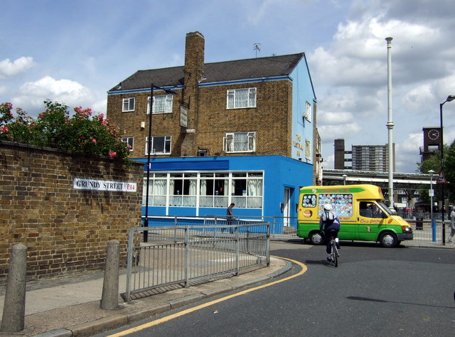
The Festival Inn Situated at the junction of Grundy Street and Kerbery Street, and backing on to Chrisp Street market with its clock tower. The pub is named for the 1951 Festival of Britain which provided the incentive for rebuilding this area of Poplar following wartime damage. |
| Date | |
| Source | From geograph.org.uk |
| Author | ceridwen |
| Attribution (required by the license) | ceridwen / The Festival Inn / |
| Camera location | | View this and other nearby images on: OpenStreetMap |
|---|
_heading:90.00&language=en)
| Object location | | View this and other nearby images on: OpenStreetMap |
|---|
_heading:90.00&language=en)
Licensing

|
This image was taken from the Geograph project collection. See this photograph's page on the Geograph website for the photographer's contact details. The copyright on this image is owned by ceridwen and is licensed for reuse under the Creative Commons Attribution-ShareAlike 2.0 license.
|
This file is licensed under the Creative Commons Attribution-Share Alike 2.0 Generic license.
Attribution: ceridwen
- You are free:
- to share – to copy, distribute and transmit the work
- to remix – to adapt the work
- Under the following conditions:
- attribution – You must give appropriate credit, provide a link to the license, and indicate if changes were made. You may do so in any reasonable manner, but not in any way that suggests the licensor endorses you or your use.
- share alike – If you remix, transform, or build upon the material, you must distribute your contributions under the same or compatible license as the original.
File history
Click on a date/time to view the file as it appeared at that time.
| Date/Time | Thumbnail | Dimensions | User | Comment | |
|---|---|---|---|---|---|
| current | 06:53, 21 February 2011 | | 640 × 474 (92 KB) | GeographBot | == {{int:filedesc}} == {{Information |description={{en|1=The Festival Inn Situated at the junction of Grundy Street and Kerbery Street, and backing on to Chrisp Street market with its clock tower. The pub is named for the 1951 Festival of Britain which pr |
File usage
The following pages on the English Wikipedia use this file (pages on other projects are not listed):