
No higher resolution available.
The_Beverley_Gate_-_geograph.org.uk_-_624987.jpg (640 × 436 pixels, file size: 93 KB, MIME type: image/jpeg)
| This is a file from the Wikimedia Commons. Information from its description page there is shown below. Commons is a freely licensed media file repository. You can help. |
Summary
| Description |
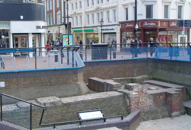
The Beverley Gate, Hull, East Riding of Yorkshire, England. The old town of Hull was protected by a fortified wall, part of which is seen here. The walls were taken down and used for lining the docks when their defensive value was reduced by the invention of gunpowder. This site, the Beverley Gate, is the position where (in April 1642) the governor of Hull, Sir John Hotham denied King Charles access to town (and hence to the arsenal of weapons), this being one of the acts which precipitated the English civil war. Beyond the site the streets are left Alfred Gelder Street, straight on to Whitefriargate, and right to Princes Dock Street. |
| Date | |
| Source | From geograph.org.uk |
| Author | Peter Church |
| Permission (Reusing this file) |
Creative Commons Attribution Share-alike license 2.0 |
| Attribution (required by the license) | Peter Church / The Beverley Gate / |
| Camera location | | View this and other nearby images on: OpenStreetMap |
|---|
_heading:135.00&language=en)
| Object location | | View this and other nearby images on: OpenStreetMap |
|---|
_heading:135.00&language=en)
Licensing

|
This image was taken from the Geograph project collection. See this photograph's page on the Geograph website for the photographer's contact details. The copyright on this image is owned by Peter Church and is licensed for reuse under the Creative Commons Attribution-ShareAlike 2.0 license.
|
This file is licensed under the Creative Commons Attribution-Share Alike 2.0 Generic license.
Attribution: Peter Church
- You are free:
- to share – to copy, distribute and transmit the work
- to remix – to adapt the work
- Under the following conditions:
- attribution – You must give appropriate credit, provide a link to the license, and indicate if changes were made. You may do so in any reasonable manner, but not in any way that suggests the licensor endorses you or your use.
- share alike – If you remix, transform, or build upon the material, you must distribute your contributions under the same or compatible license as the original.
File history
Click on a date/time to view the file as it appeared at that time.
| Date/Time | Thumbnail | Dimensions | User | Comment | |
|---|---|---|---|---|---|
| current | 07:09, 7 February 2011 | | 640 × 436 (93 KB) | GeographBot | == {{int:filedesc}} == {{Information |description={{en|1=The Beverley Gate The old town of Hull was protected by a fortified wall, part of which is seen here. The walls were taken down and used for lining the docks when their defensive value was reduced |
File usage
The following pages on the English Wikipedia use this file (pages on other projects are not listed):
Global file usage
The following other wikis use this file:
- Usage on da.wikipedia.org