

Size of this JPG preview of this TIF file: 578 × 599 pixels. Other resolutions: 231 × 240 pixels | 463 × 480 pixels | 741 × 768 pixels | 988 × 1,024 pixels | 1,632 × 1,692 pixels.
Original file (1,632 × 1,692 pixels, file size: 15.83 MB, MIME type: image/tiff)
| This is a file from the Wikimedia Commons. Information from its description page there is shown below. Commons is a freely licensed media file repository. You can help. |
Summary
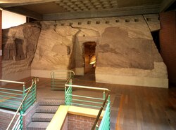
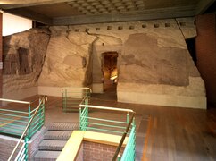
| Temple of Ellesyia
|
|||||||||||||||||||||
|---|---|---|---|---|---|---|---|---|---|---|---|---|---|---|---|---|---|---|---|---|---|
| Title |
Temple of Ellesyia |
 | |||||||||||||||||||
| Object type |
temple / temple / work of art |
||||||||||||||||||||
| Date |
after 1454 BC New Kingdom of Egypt (circa 1550 BC–1070 BC) |
||||||||||||||||||||
| Medium |
sandstone |
||||||||||||||||||||
| Dimensions |
height: 850 cm (27.8 ft) |
||||||||||||||||||||
| Collection |
|
||||||||||||||||||||
| Current location | |||||||||||||||||||||
| Accession number |
S. 18016 (Museo Egizio) |
||||||||||||||||||||
| Object location |
|
||||||||||||||||||||
| Place of discovery |
Nubia |
||||||||||||||||||||
| Object history |
|
||||||||||||||||||||
| References | |||||||||||||||||||||
| Source/Photographer |
|
||||||||||||||||||||
| Other versions |
|
||||||||||||||||||||


Licensing
This file is licensed under the Creative Commons Attribution 2.5 Generic license.
- You are free:
- to share – to copy, distribute and transmit the work
- to remix – to adapt the work
- Under the following conditions:
- attribution – You must give appropriate credit, provide a link to the license, and indicate if changes were made. You may do so in any reasonable manner, but not in any way that suggests the licensor endorses you or your use.
File history
Click on a date/time to view the file as it appeared at that time.
| Date/Time | Thumbnail | Dimensions | User | Comment | |
|---|---|---|---|---|---|
| current | 07:05, 23 April 2023 |  | 1,632 × 1,692 (15.83 MB) | Elemar (WMIT) | upload pics of ME S. 18016 (details) |
File usage
The following pages on the English Wikipedia use this file (pages on other projects are not listed):
Global file usage
The following other wikis use this file:
- Usage on ar.wikipedia.org
- Usage on arz.wikipedia.org
- Usage on fr.wikipedia.org