
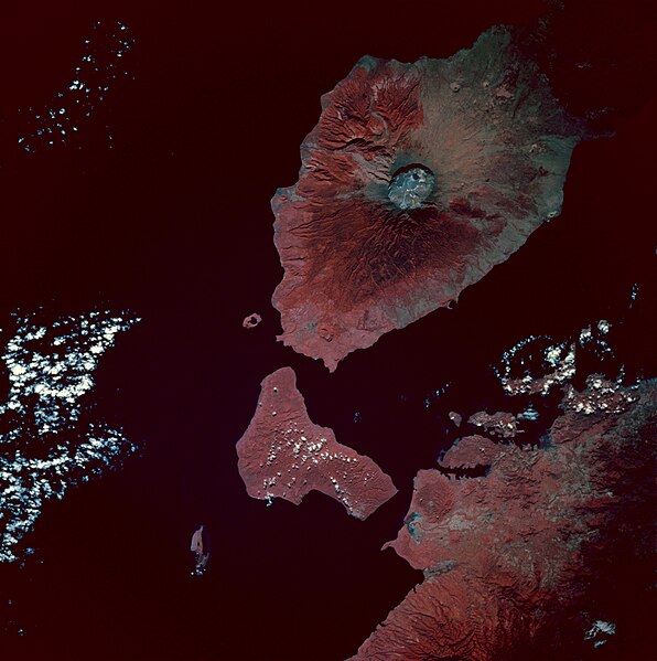
![Infrared image of Mount Tambora, Sumbawa Island, Indonesia. Taken from the space shuttle Endeavour at 0:54 GMT on 13 May 1992. Description from [1]: The most striking geologic feature in this photograph is the large circular Tambora Volcano caldera, the diameter of which is slightly more than 3 miles (5 kilometers). Prior to the disastrous eruption of 1815 when the volcano blew away most of its top, Tambora’s summit was approximately 13 000 feet (4000 meters) above sea level. The present elevation of the caldera rim is more than 9000 feet (2700 meters) above sea level. Many geologists and volcanologists rank the 1815 eruption among the 10 most explosive eruptions of the modern era. Tambora, a classic stratovolcano with steep slopes and a symmetrical shape, is located on the north-central coast of Sumbawa Island, Indonesia, which is bordered on the north by the Flores Sea and on the southwest by Teluk Saleh Bay. Color infrared film, which displays green vegetation in varying shades of red, accentuates the distribution patterns of dense tropical vegetation surrounding the volcano and other land areas in the photograph.](http://upload.wikimedia.org/wikipedia/commons/e/e5/Tambora_EFS_highres_STS049_STS049-97-54.jpg)
Size of this preview: 596 × 599 pixels. Other resolutions: 239 × 240 pixels | 477 × 480 pixels | 764 × 768 pixels | 1,018 × 1,024 pixels | 2,037 × 2,048 pixels | 3,940 × 3,962 pixels.
Original file (3,940 × 3,962 pixels, file size: 2.61 MB, MIME type: image/jpeg)
| This is a file from the Wikimedia Commons. Information from its description page there is shown below. Commons is a freely licensed media file repository. You can help. |
Summary
| Description |
Infrared image of Mount Tambora, Sumbawa Island, Indonesia. Taken from the space shuttle Endeavour at 0:54 GMT on 13 May 1992.
|
| Date | |
| Source | [2] |
| Author | Image Science and Analysis Laboratory, NASA-Johnson Space Center. "The Gateway to Astronaut Photography of Earth". |
Licensing
| This file is in the public domain in the United States because it was solely created by NASA. NASA copyright policy states that "NASA material is not protected by copyright unless noted". (See Template:PD-USGov, NASA copyright policy page or JPL Image Use Policy.) | ||
 |
Warnings:
|
File history
Click on a date/time to view the file as it appeared at that time.
| Date/Time | Thumbnail | Dimensions | User | Comment | |
|---|---|---|---|---|---|
| current | 08:49, 8 February 2010 | | 3,940 × 3,962 (2.61 MB) | Avenue | {{Information |Description=Infrared image of Mount Tambora, Sumbawa Island, Indonesia. Taken from the space shuttle Endeavour at 0:54 GMT on 13 May 1992. <br/>Description from [http://city.jsc.nasa.gov/sseop/EFS/photoinfo.pl?PHOTO=STS049-97-54]:<br/> The |
File usage
The following pages on the English Wikipedia use this file (pages on other projects are not listed):
Global file usage
The following other wikis use this file:
- Usage on ar.wikipedia.org
- Usage on ast.wikipedia.org
- Usage on bn.wikipedia.org
- Usage on br.wikipedia.org
- Usage on el.wikipedia.org
- Usage on es.wikipedia.org
- Usage on id.wikipedia.org
- Usage on mk.wikipedia.org
- Usage on ms.wikipedia.org
- Usage on pt.wikipedia.org
- Usage on ro.wikipedia.org
- Usage on tr.wikipedia.org
- Tambora Dağı
- 1815 Tambora Dağı patlaması
- Kullanıcı:Anerka/Takip/Biliyor muydunuz?
- Kullanıcı:LostMyMind/BM logları
- Vikipedi:Biliyor muydunuz?/Arşiv/2022+
- Vikipedi:Biliyor muydunuz?/2023-03-05
- Vikipedi:Biliyor muydunuz/Mart 2023
- Vikipedi:Biliyor muydunuz/Şubat 2024
- Vikipedi:Biliyor muydunuz?/2024-02-13
- Usage on zh.wikipedia.org