

Size of this preview: 800 × 533 pixels. Other resolutions: 320 × 213 pixels | 640 × 427 pixels | 1,024 × 683 pixels | 1,500 × 1,000 pixels.
Original file (1,500 × 1,000 pixels, file size: 279 KB, MIME type: image/jpeg)
| This is a file from the Wikimedia Commons. Information from its description page there is shown below. Commons is a freely licensed media file repository. You can help. |
| Description |
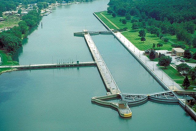
Aerial view of T.J. O’Brien Lock and Dam on the Calumet River, which is part of the Illinois Waterway. The dam is situated at river mile 326.5 on the Waterway (326.5 river miles up from the Mississippi River). T.J. O’Brien lock is the uppermost lock on the waterway, and there is not another barrier between the lock and Lake Michigan. There is very little elevation change in the lock, which serves mainly to regulate water flow from Lake Michigan into the waterway. The dam is located in Chicago, Illinois. |
|||
| Date | ||||
| Source |
U.S. Army Corps of Engineers Digital Visual Library Image page Image description page Digital Visual Library home page |
|||
| Author | Carol Arney, U.S. Army Corps of Engineers | |||
| Permission (Reusing this file) |
|
|||
| Location | Chicago, Illinois, USA |
| Camera location | | View this and other nearby images on: OpenStreetMap |
|---|
File history
Click on a date/time to view the file as it appeared at that time.
| Date/Time | Thumbnail | Dimensions | User | Comment | |
|---|---|---|---|---|---|
| current | 00:50, 3 April 2007 | | 1,500 × 1,000 (279 KB) | DanMS | {{Information | Description = {{en|Aerial view of T. J. O’Brien Lock and Dam on the Calumet River, which is part of the Illinois Waterway. The dam is situated at river mile 326 on the Waterway (326 river miles up from the Mississippi River). T.J. O� |
File usage
The following pages on the English Wikipedia use this file (pages on other projects are not listed):
Global file usage
The following other wikis use this file:
- Usage on arz.wikipedia.org
- Usage on ceb.wikipedia.org
- Usage on de.wikipedia.org
- Usage on eo.wikipedia.org
- Usage on fr.wikipedia.org
- Usage on la.wikipedia.org
- Usage on lt.wikipedia.org
- Usage on www.wikidata.org