To install click the Add extension button. That's it.

The source code for the WIKI 2 extension is being checked by specialists of the Mozilla Foundation, Google, and Apple. You could also do it yourself at any point in time.

4,5
Kelly Slayton
Congratulations on this excellent venture… what a great idea!
Alexander Grigorievskiy
I use WIKI 2 every day and almost forgot how the original Wikipedia looks like.
Live Statistics
English Articles
Improved in 24 Hours
Added in 24 Hours
What we do. Every page goes through several hundred of perfecting techniques; in live mode. Quite the same Wikipedia. Just better.
.
Leo
Newton
Brights
Milds

File:Survey of Palestine 1942-1958 1-100,000 sheet index georef.png

From Wikipedia, the free encyclopedia

Original file(9,462 × 30,152 pixels, file size: 423.13 MB, MIME type: image/png)

Summary

Warning The original file is very high-resolution. It might not load properly or could cause your browser to freeze when opened at full size. Open in ZoomViewer
Description
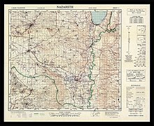
Survey of Palestine 1942-1958 1-100,000 maps sheet index combined from 24 images by Survey Department of Palestine. Each map georeferenced using CRS EPS:28191 - Palestine 1923.
Date
Source Own work
Author DutchTreat
Permission
(Reusing this file)
w:en:Creative Commons
attribution share alike
Attribution: DutchTreat
You are free:
  • to share – to copy, distribute and transmit the work
  • to remix – to adapt the work
Under the following conditions:
  • attribution – You must give appropriate credit, provide a link to the license, and indicate if changes were made. You may do so in any reasonable manner, but not in any way that suggests the licensor endorses you or your use.
  • share alike – If you remix, transform, or build upon the material, you must distribute your contributions under the same or compatible license as the original.
Public domain
This work created by the United Kingdom Government is in the public domain.

This is because it is one of the following:

  1. It is a photograph taken prior to 1 June 1957; or
  2. It was published prior to 1974; or
  3. It is an artistic work other than a photograph or engraving (e.g. a painting) which was created prior to 1974.

HMSO has declared that the expiry of Crown Copyrights applies worldwide (ref: HMSO Email Reply)
More information.

See also Copyright and Crown copyright artistic works.

Deutsch  English  Español  français  italiano  Nederlands  polski  português  sicilianu  slovenščina  suomi  Türkçe  македонски  русский  українська  മലയാളം  한국어  日本語  简体中文  繁體中文  العربية  +/−

Public domain
This work was created or ordered by the State of Israel, and is in the public domain because it satisfies one of the conditions stipulated in Israel's copyright statute from 2007 (translation) regarding the State's copyrights:
  1. It is a statute, regulation, Knesset protocol or court decision and therefore ineligible for copyright protection according to §6 of the 2007 statute; OR
  2. It was created more than 50 years ago (i.e. before 1 January 1974), and the State's copyright has therefore expired according to §§42–43 of the 2007 statute PROVIDING THAT
  • The State of Israel was the first owner of copyrights on this work; AND
  • The State did not waive its copyrights in a special contract with the author when this work was created.

English  русский  中文  हिन्दी  עברית  العربية  +/−

Other versions Survey of Palestine 1942-1958 1-100,000 sheet index georef white bg.jpg Survey of Palestine 1942-1958 1-100,000 sheet index.png
Camera location33° 06′ 54.1″ N, 35° 12′ 33.8″ E Kartographer map based on OpenStreetMap.View this and other nearby images on: OpenStreetMapinfo

Wikipedia

 This is a featured picture on the English language Wikipedia (Featured pictures) and is considered one of the finest images. See its nomination here.

If you think this file should be featured on Wikimedia Commons as well, feel free to nominate it.
If you have an image of similar quality that can be published under a suitable copyright license, be sure to upload it, tag it, and nominate it.

The first five 1-100,0000 maps of the set of twenty-four:

Licensing

I, the copyright holder of this work, hereby publish it under the following license:
w:en:Creative Commons
attribution share alike
You are free:
  • to share – to copy, distribute and transmit the work
  • to remix – to adapt the work
Under the following conditions:
  • attribution – You must give appropriate credit, provide a link to the license, and indicate if changes were made. You may do so in any reasonable manner, but not in any way that suggests the licensor endorses you or your use.
  • share alike – If you remix, transform, or build upon the material, you must distribute your contributions under the same or compatible license as the original.

Captions

Survey of Palestine 1942-1958 1-100,000 maps sheet index

Items portrayed in this file

depicts

9 September 2020

33°6'54.101"N, 35°12'33.800"E

File history

Click on a date/time to view the file as it appeared at that time.

Date/TimeThumbnailDimensionsUserComment
current11:24, 16 September 2020Thumbnail for version as of 11:24, 16 September 20209,462 × 30,152 (423.13 MB)DutchTreatc:User:Rillke/bigChunkedUpload.js:
11:54, 9 September 2020Thumbnail for version as of 11:54, 9 September 202010,008 × 30,437 (424.41 MB)DutchTreatUploaded own work with UploadWizard
The following pages on the English Wikipedia use this file (pages on other projects are not listed):

Global file usage

The following other wikis use this file:

Metadata

This page was last edited on 21 November 2022, at 04:12
Basis of this page is in Wikipedia. Text is available under the CC BY-SA 3.0 Unported License. Non-text media are available under their specified licenses. Wikipedia® is a registered trademark of the Wikimedia Foundation, Inc. WIKI 2 is an independent company and has no affiliation with Wikimedia Foundation.