
No higher resolution available.
Stepney_Green,_Stepney_Green_Court,_E1_-_geograph.org.uk_-_786319.jpg (640 × 480 pixels, file size: 119 KB, MIME type: image/jpeg)
| This is a file from the Wikimedia Commons. Information from its description page there is shown below. Commons is a freely licensed media file repository. You can help. |
Summary
| Description |
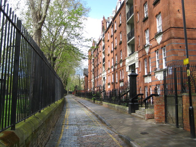
Stepney Green: Stepney Green Court, E1 The building on the right is Stepney Green Court, formerly Stepney Dwellings. It was built in 1896 by the 4% Industrial Dwellings Company. This Jewish company, chaired by Nathaniel, Lord Rothschild, built good quality, but low rent, accommodation for the working poor of the East End. The Rothschilds raised the money for the construction from wealthy Jewish businessmen on the understanding that the profits for the shareholders would be limited to 4%.
The cobbled street is defaced with the usual over-zealous yellow lining. |
| Date | |
| Source | From geograph.org.uk |
| Author | Nigel Cox |
| Attribution (required by the license) | Nigel Cox / Stepney Green: Stepney Green Court, E1 / |
| Camera location | | View this and other nearby images on: OpenStreetMap |
|---|
_heading:315.00&language=en)
| Object location | | View this and other nearby images on: OpenStreetMap |
|---|
_heading:315.00&language=en)
Licensing

|
This image was taken from the Geograph project collection. See this photograph's page on the Geograph website for the photographer's contact details. The copyright on this image is owned by Nigel Cox and is licensed for reuse under the Creative Commons Attribution-ShareAlike 2.0 license.
|
This file is licensed under the Creative Commons Attribution-Share Alike 2.0 Generic license.
Attribution: Nigel Cox
- You are free:
- to share – to copy, distribute and transmit the work
- to remix – to adapt the work
- Under the following conditions:
- attribution – You must give appropriate credit, provide a link to the license, and indicate if changes were made. You may do so in any reasonable manner, but not in any way that suggests the licensor endorses you or your use.
- share alike – If you remix, transform, or build upon the material, you must distribute your contributions under the same or compatible license as the original.
File history
Click on a date/time to view the file as it appeared at that time.
| Date/Time | Thumbnail | Dimensions | User | Comment | |
|---|---|---|---|---|---|
| current | 02:33, 20 February 2011 | | 640 × 480 (119 KB) | GeographBot | == {{int:filedesc}} == {{Information |description={{en|1=Stepney Green: Stepney Green Court, E1 The building on the right is Stepney Green Court, formerly Stepney Dwellings. It was built in 1896 by the 4% Industrial Dwellings Company. This Jewish company, |
File usage
The following pages on the English Wikipedia use this file (pages on other projects are not listed):
Global file usage
The following other wikis use this file:
- Usage on af.wikipedia.org
- Usage on ga.wikipedia.org