
Size of this preview: 683 × 599 pixels. Other resolutions: 274 × 240 pixels | 547 × 480 pixels | 881 × 773 pixels.
Original file (881 × 773 pixels, file size: 102 KB, MIME type: image/png)
| This is a file from the Wikimedia Commons. Information from its description page there is shown below. Commons is a freely licensed media file repository. You can help. |
Summary
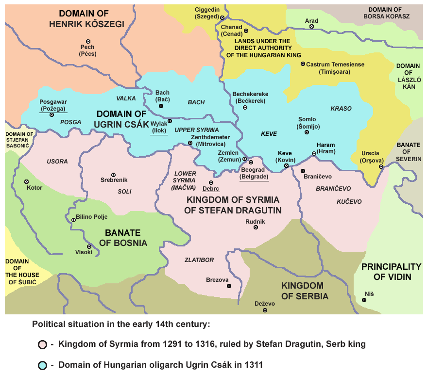
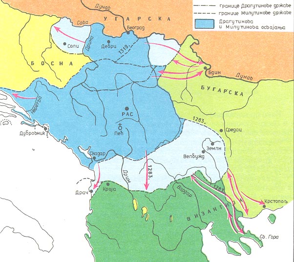
- English: Map of the realm of Stefan Dragutin and domain of Ugrin Csák (13th-14th century).
- Serbian: Мапа државе Стефана Драгутина и области Угрина Чака (13-14. век).
Source and licence

|
This map has been uploaded by Electionworld from en.wikipedia.org to enable the |
Self-made map by PANONIAN
| This work has been released into the public domain by its author, PANONIAN. This applies worldwide. In some countries this may not be legally possible; if so: |
References
- Istorijski atlas, Geokarta, Beograd, 1999.
- Dragan Brujić, Vodič kroz svet Vizantije, Beograd, 2004.
- Dr Tomislav Bogavac, Nestajanje Srba, Niš, 1994.
- Sima M. Ćirković, Srbi među evropskim narodima, Beograd, 2004.
- Školski istorijski atlas, Zavod za izdavanje udžbenika SR Srbije, Beograd, 1970.
- Povijesni atlas, Učila - Zagreb, Zagreb, 1971.
- Vladimir Ćorović, Ilustrovana istorija Srba, knjiga druga, Beograd, 2005.
- Stanoje Stanojević, Istorija srpskog naroda, Beograd, 2009.
- Miloš Blagojević, Srbija Nemanjića i Hilandar, Novi Sad, 1998.
- Sve srpske mape - od šestog veka do Pariza, specijalno izdanje BLICA, Decembar 1995. godine.
- Dr Životije Đorđević, Kosovo i Metohija kroz vekove, Jagodina, 2009.
- Petrit Imami, Srbi i Albanci kroz vekove, Beograd, 2000.
- Peter Rokai - Zoltan Đere - Tibor Pal - Aleksandar Kasaš, Istorija Mađara, Beograd, 2002.
- http://www.rgz.gov.rs/kart-proizvodi/artikli%5C052610.jpg
- http://www.arhiva.srbija.gov.rs/g3/images/dragutin_i_milutin_drzava.jpg
- http://www.rodnikraj.eu/index_htm_files/240.png
- http://www.sulinet.hu/eletmod/hogyantovabb/tovabbtanulas/elokeszito/tortenelem/4het/terkep.jpg
- http://mek.niif.hu/00900/00940/html/img/nagy/420e.jpg
- http://www.conflicts.rem33.com/images/Ungarn/Ungarn%20Anjou%20XIV.jpg
- http://www.conflicts.rem33.com/images/Ungarn/Polen%20Boehmen%20Ungarn%201197-1306.JPG
- http://img440.imageshack.us/img440/8347/kiskiralyokvc8.jpg
- http://www.bolterandchainsword.com/uploads/1291387383/gallery_21152_4921_257811.png
File history
Click on a date/time to view the file as it appeared at that time.
| Date/Time | Thumbnail | Dimensions | User | Comment | |
|---|---|---|---|---|---|
| current | 08:34, 24 April 2015 | | 881 × 773 (102 KB) | PANONIAN | Reverted to version as of 16:09, 13 April 2015 |
| 08:32, 24 April 2015 |  | 881 × 773 (101 KB) | PANONIAN | Reverted to version as of 21:48, 26 November 2014 | |
| 16:09, 13 April 2015 |  | 881 × 773 (102 KB) | PANONIAN | corrections | |
| 21:48, 26 November 2014 |  | 881 × 773 (101 KB) | PANONIAN | corrections | |
| 14:08, 18 April 2011 |  | 885 × 773 (101 KB) | PANONIAN | aesthetics | |
| 15:54, 24 June 2009 |  | 885 × 773 (110 KB) | PANONIAN | ||
| 18:30, 27 March 2009 |  | 885 × 773 (109 KB) | PANONIAN | ||
| 17:11, 26 March 2009 |  | 885 × 773 (106 KB) | PANONIAN | ||
| 21:37, 21 December 2006 |  | 716 × 662 (16 KB) | Electionworld | {{ew|en|PANONIAN}} Self-made map by PANONIAN {{PD-user|PANONIAN}} Category:Maps of Serbia |
File usage
The following pages on the English Wikipedia use this file (pages on other projects are not listed):
Global file usage
The following other wikis use this file:
- Usage on ast.wikipedia.org
- Usage on be.wikipedia.org
- Usage on bg.wikipedia.org
- Usage on ca.wikipedia.org
- Usage on cs.wikipedia.org
- Usage on de.wikipedia.org
- Usage on el.wikipedia.org
- Usage on fr.wikipedia.org
- Usage on gl.wikipedia.org
- Usage on he.wikipedia.org
- Usage on hr.wikipedia.org
- Usage on id.wikipedia.org
- Usage on it.wikipedia.org
- Usage on ja.wikipedia.org
- Usage on lt.wikipedia.org
- Usage on mk.wikipedia.org
- Usage on nl.wikipedia.org
- Usage on pl.wikipedia.org
- Usage on ru.wikipedia.org
- Usage on sh.wikipedia.org
- Usage on sl.wikipedia.org
- Usage on sr.wikipedia.org
- Usage on tr.wikipedia.org
- Usage on uk.wikipedia.org