

Size of this PNG preview of this SVG file: 742 × 600 pixels. Other resolutions: 297 × 240 pixels | 594 × 480 pixels | 950 × 768 pixels | 1,267 × 1,024 pixels | 2,533 × 2,048 pixels | 2,419 × 1,956 pixels.
Original file (SVG file, nominally 2,419 × 1,956 pixels, file size: 134 KB)
| This is a file from the Wikimedia Commons. Information from its description page there is shown below. Commons is a freely licensed media file repository. You can help. |
Summary
| Description |
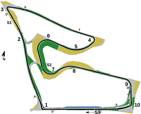
This is a map of the w:en:Red Bull Ring, formerly known as the A1-Ring and the Österreichring, in w:en:Spielberg, Austria. It shows the circuit roughly as it has been in the period spanning 2014-2021. Corner numbers are marked with the numbers "1" through "10", the start/finish line is marked as "S/F" with an arrow showing a direction of travel. The marker "S1" shows the end of the first sector, and the marker "S2" shows the end of the second sector. The markers labelled "D" show the w:en:Drag Reduction System detection points for w:en:Formula One, while the markers labelled "A" shows the activation points. The marker labelled "T" shows the speed trap used in Formula One. The location of these markers was sourced from the FIA's official Formula One circuit map. The arrow marked "N" shows the direction of north. The track layout and pit lane entrance and exit are shown in black with a white outline, while the pit lane itself is shown in blue. Green areas mark grass run-off areas, grey areas mark paved run-off areas, and yellow areas mark gravel traps. |
| Date | |
| Source | Planet Labs, image also available on Wikimedia Commons |
| Author | I, User:HumanBodyPiloter5, created this SVG map as a derivative work based on the satellite image of the Spielberg circuit released by w:en:Planet Labs under CC-BY-SA 4.0 in 2018 |
Licensing
This file is licensed under the Creative Commons Attribution-Share Alike 4.0 International license.
- You are free:
- to share – to copy, distribute and transmit the work
- to remix – to adapt the work
- Under the following conditions:
- attribution – You must give appropriate credit, provide a link to the license, and indicate if changes were made. You may do so in any reasonable manner, but not in any way that suggests the licensor endorses you or your use.
- share alike – If you remix, transform, or build upon the material, you must distribute your contributions under the same or compatible license as the original.
File history
Click on a date/time to view the file as it appeared at that time.
| Date/Time | Thumbnail | Dimensions | User | Comment | |
|---|---|---|---|---|---|
| current | 19:57, 26 June 2021 | | 2,419 × 1,956 (134 KB) | HumanBodyPiloter5 | Uploaded a work by I, User:HumanBodyPiloter5, created this SVG map as a derivative work based on the satellite image of the Spielberg circuit released by Planet Labs under CC-BY-SA 4.0 in 2018 from [https://medium.com/planet-stories/a-grand-prix-world-tour-86b08d45ae46 Planet Labs], image also available [https://commons.wikimedia.org/wiki/File:Red_Bull_Ring,_April_18,_2018_SkySat.jpg on Wikimedia Commons] with UploadWizard |
File usage
The following pages on the English Wikipedia use this file (pages on other projects are not listed):
Global file usage
The following other wikis use this file:
- Usage on cs.wikipedia.org
- Usage on gl.wikipedia.org