

Size of this preview: 800 × 390 pixels. Other resolutions: 320 × 156 pixels | 640 × 312 pixels | 1,000 × 488 pixels.
Original file (1,000 × 488 pixels, file size: 76 KB, MIME type: image/png)
| This is a file from the Wikimedia Commons. Information from its description page there is shown below. Commons is a freely licensed media file repository. You can help. |
Summary
| Description |
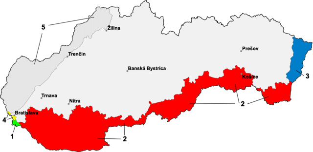
Map of Slovakia with border-changes in the south and east against Hungary & Germany (1939-1945)
|
| Date | |
| Source |
|
| Author | Martin Proehl / Murli |
| Other versions | File:Slovakia borderHungary hu.svg |
Licensing
I, the copyright holder of this work, hereby publish it under the following licenses:

|
Permission is granted to copy, distribute and/or modify this document under the terms of the GNU Free Documentation License, Version 1.2 or any later version published by the Free Software Foundation; with no Invariant Sections, no Front-Cover Texts, and no Back-Cover Texts. A copy of the license is included in the section entitled GNU Free Documentation License. |
| This file is licensed under the Creative Commons Attribution-Share Alike 3.0 Unported license. | ||
| ||
| This licensing tag was added to this file as part of the GFDL licensing update. |
This file is licensed under the Creative Commons Attribution-Share Alike 2.5 Generic, 2.0 Generic and 1.0 Generic license.
- You are free:
- to share – to copy, distribute and transmit the work
- to remix – to adapt the work
- Under the following conditions:
- attribution – You must give appropriate credit, provide a link to the license, and indicate if changes were made. You may do so in any reasonable manner, but not in any way that suggests the licensor endorses you or your use.
- share alike – If you remix, transform, or build upon the material, you must distribute your contributions under the same or compatible license as the original.
You may select the license of your choice.
File history
Click on a date/time to view the file as it appeared at that time.
| Date/Time | Thumbnail | Dimensions | User | Comment | |
|---|---|---|---|---|---|
| current | 19:00, 22 June 2014 | | 1,000 × 488 (76 KB) | Kopiersperre | optipng |
| 00:37, 18 April 2006 |  | 1,000 × 488 (95 KB) | Murli | corrected protection zone, thx to Juro | |
| 20:42, 17 April 2006 |  | 1,000 × 488 (88 KB) | Murli | added german "protection zone" | |
| 19:32, 17 April 2006 |  | 1,000 × 488 (72 KB) | Murli | better version without kraj-borders | |
| 10:12, 17 April 2006 |  | 1,000 × 488 (93 KB) | Murli | german borders added | |
| 17:06, 16 April 2006 |  | 1,000 × 488 (92 KB) | Murli | *map of Slovakia with border-changes in the south and east against Hungary *selfprovided on April 16th, 2006 *1 - Bratislava bridgehead, until 15 october 1947 part of Hungary *2 - southern Slovakia, from 2 november 1938 until 1945/47 to Hungary due to the |
File usage
The following pages on the English Wikipedia use this file (pages on other projects are not listed):
Global file usage
The following other wikis use this file:
- Usage on als.wikipedia.org
- Usage on ar.wikipedia.org
- Usage on azb.wikipedia.org
- Usage on az.wikipedia.org
- Usage on ba.wikipedia.org
- Usage on be-tarask.wikipedia.org
- Usage on be.wikipedia.org
- Usage on bg.wikipedia.org
- Usage on ca.wikipedia.org
- Usage on cs.wikipedia.org
- Usage on da.wikipedia.org
- Usage on de.wikipedia.org
- Geschichte der Slowakei
- Wiener Schiedsspruch
- Bratislavaer Brückenkopf
- Slowakisch-Ungarischer Krieg
- Slowakischer Staat
- Erster Wiener Schiedsspruch
- Benutzer:3mnaPashkan/Geschichte der Slowakei
- Tschecho-Slowakische Republik
- Benutzer:3mnaPashkan/Slowakische Armee (1939 bis 1945)
- Deutsch-slowakische Beziehungen
- Usage on el.wikipedia.org
- Usage on en.wikiversity.org
- Usage on eo.wikipedia.org
- Usage on et.wikipedia.org
- Usage on fi.wikipedia.org
- Usage on fr.wikipedia.org
- Usage on he.wikipedia.org
- Usage on hu.wikipedia.org
- Usage on hy.wikipedia.org
- Usage on it.wikipedia.org
View more global usage of this file.