

Size of this PNG preview of this SVG file: 456 × 600 pixels. Other resolutions: 182 × 240 pixels | 365 × 480 pixels | 584 × 768 pixels | 779 × 1,024 pixels | 1,558 × 2,048 pixels | 1,128 × 1,483 pixels.
Original file (SVG file, nominally 1,128 × 1,483 pixels, file size: 810 KB)
| This is a file from the Wikimedia Commons. Information from its description page there is shown below. Commons is a freely licensed media file repository. You can help. |
Summary
| Description |
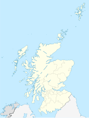
Quadratische Plattkarte, N-S-Streckung 170 %. Geographische Begrenzung der Karte:
Location map of Scotland, United Kingdom
Equirectangular projection, N/S stretching 170 %. Geographic limits of the map:
|
||
| Date | 9 October 2008 (upload date) | ||
| Source |
own work, using
|
||
| Author | NordNordWest | ||
| Other versions |
Derivative works of this file:
|
||
| SVG development |
|


Licensing
I, the copyright holder of this work, hereby publish it under the following licenses:

|
Permission is granted to copy, distribute and/or modify this document under the terms of the GNU Free Documentation License, Version 1.2 or any later version published by the Free Software Foundation; with no Invariant Sections, no Front-Cover Texts, and no Back-Cover Texts. A copy of the license is included in the section entitled GNU Free Documentation License. |
This file is licensed under the Creative Commons Attribution-Share Alike 3.0 Unported license.
Attribution: Eric Gaba, NordNordWest
- You are free:
- to share – to copy, distribute and transmit the work
- to remix – to adapt the work
- Under the following conditions:
- attribution – You must give appropriate credit, provide a link to the license, and indicate if changes were made. You may do so in any reasonable manner, but not in any way that suggests the licensor endorses you or your use.
- share alike – If you remix, transform, or build upon the material, you must distribute your contributions under the same or compatible license as the original.
You may select the license of your choice.
File history
Click on a date/time to view the file as it appeared at that time.
| Date/Time | Thumbnail | Dimensions | User | Comment | |
|---|---|---|---|---|---|
| current | 18:27, 9 October 2008 | | 1,128 × 1,483 (810 KB) | NordNordWest | {{Information |Description= {{de|Positionskarte von Schottland, Vereinigtes Königreich}} Quadratische Plattkarte, N-S-Streckung 170 %. Geographische Begrenzung der Karte: * N: 61.0° N * S: 54.5° N * W: |
File usage
More than 100 pages use this file. The following list shows the first 100 pages that use this file only. A full list is available.
- Aberlady
- Achnashellach Forest
- Ancient universities of Scotland
- Arbroath Abbey
- Archiestown
- Auchenshuggle
- Ayr
- Baillieston
- Bargeddie
- Barlanark
- Barnton, Edinburgh
- Barrhead
- Battle of Nesbit Moor (1402)
- Bearsden
- Bishopbriggs
- Bridgeton, Glasgow
- British Rail Class 17
- British Rail Class 26
- British Rail Class 47
- Broughty Ferry
- Bruntsfield
- Calton, Glasgow
- Cambuslang
- Camperdown, Dundee
- Carmunnock
- Carmyle
- Carse of Gowrie
- Cathcart
- Clydebank
- Cockenzie and Port Seton
- Colston, Glasgow
- Corgarff Castle
- Corstorphine
- Craigievar Castle
- Cramond
- Crossmyloof
- Cults, Aberdeen
- Davidson's Mains
- Dean Village
- Delgatie Castle
- Drumlanrig Castle
- Duddingston
- Dunbar
- Dunfermline Abbey
- Dunglass
- Dyce
- East Fortune
- East Kilbride
- East Linton
- Edinburgh Airport
- Giffnock
- Glasgow Prestwick Airport
- Gorgie
- Govan
- Grangemouth
- HM Prison Low Moss
- Haddington, East Lothian
- Hardgate
- Haymarket, Edinburgh
- Hunterian Museum and Art Gallery
- Inveresk
- Iona Abbey
- John Knox House
- Kilmarnock
- Kilrenny
- Kirkintilloch
- Kirkliston
- Leith
- Lenzie
- Limes (Roman Empire)
- Lochee
- Longniddry
- Mannofield
- Marchmont
- Maryhill
- Morningside, Edinburgh
- National Museum of Flight
- Newhaven, Edinburgh
- Newington, Edinburgh
- Newton Mearns
- North Berwick
- Old Aberdeen
- Ormiston
- Pencaitland
- Peterculter
- Portobello, Edinburgh
- Ralston, Renfrewshire
- Royal Troon Golf Club
- Rutherglen
- Sciennes
- Scotland national cricket team
- Scottish National League (ice hockey)
- Smoo Cave
- South Queensferry
- Stirling Castle
- Stobswell
- Swanston, Edinburgh
- Thornliebank
- Tranent
- Turnberry (golf course)
View more links to this file.
Global file usage
The following other wikis use this file:
- Usage on ab.wikipedia.org
- Usage on af.wikipedia.org
- Gebruiker:Laurens
- Rugbywêreldbeker 2007
- Skerryvore
- Sjabloon:Liggingkaart Skotland
- Aberdeen (dubbelsinnig)
- Auchtermuchty
- Inverness
- Kirkwall
- Gruinard-eiland
- Lockerbie
- Ben Nevis
- Skara Brae
- Govan
- Verenigde Rugbykampioenskap
- Aberfoyle, Stirling
- Alloway
- Skotse nasionale krieketspan
- Dumfries
- Glen Coe
- Bonnybridge
- Ayr
- Luss
- Usage on ar.wikipedia.org
- Usage on arz.wikipedia.org
- Usage on ast.wikipedia.org
- Usage on azb.wikipedia.org
View more global usage of this file.