

Size of this preview: 521 × 600 pixels. Other resolutions: 208 × 240 pixels | 417 × 480 pixels | 667 × 768 pixels | 889 × 1,024 pixels | 1,778 × 2,048 pixels | 5,279 × 6,079 pixels.
Original file (5,279 × 6,079 pixels, file size: 4.02 MB, MIME type: image/jpeg)
| This is a file from the Wikimedia Commons. Information from its description page there is shown below. Commons is a freely licensed media file repository. You can help. |
Summary
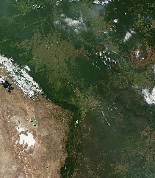
| Description | Satellite image of Bolivia in June 2002. Normally obscured by clouds, Bolivia is amazingly clear in this true-color MODIS image acquired June 20, 2002. Bounded by Brazil to the north and east, Paraguay and Argentina to the south, and Peru and Chile to the west, Bolivia is completely landlocked. A good portion of Bolivia is dominated by the Andes, but it also lays claim to lush forests and pasture lands in the Amazon Basin.Bolivia's agricultural crops include soybeans, coffee, coca, cotton, corn, sugarcane, rice, potatoes, and timber. A number of agricultural plots are visible in central Bolivia. Some large plots are arranged in a circular star shape, with water sources at the center and the agricultural plots radiating outwards. Adjacent to them (down and to the right) are more traditional shaped plots (more rectangular).One of Bolivia's main exports is tropical timber. Visible in this image are areas where the timber has been harvested. The deforestation patterns tend to follow major roads first, then smaller roads adjoining main roads. These patterns resemble the growth of ice crystals and are best viewed in the higher resolutions of this image. Deforestation is visible along the green edge of the Andes in central Bolivia. |
| Date | |
| Source | Slightly cropped from: http://visibleearth.nasa.gov/view_rec.php?id=3261 |
| Author | Jacques Descloitres, MODIS Land Rapid Response Team, NASA/GSFC |
Licensing
| This file is in the public domain in the United States because it was solely created by NASA. NASA copyright policy states that "NASA material is not protected by copyright unless noted". (See Template:PD-USGov, NASA copyright policy page or JPL Image Use Policy.) | ||
 |
Warnings:
|
File history
Click on a date/time to view the file as it appeared at that time.
| Date/Time | Thumbnail | Dimensions | User | Comment | |
|---|---|---|---|---|---|
| current | 16:40, 18 December 2004 | | 5,279 × 6,079 (4.02 MB) | <bdi>Hautala</bdi> | {{PD-USGov-NASA}} Satellite image of Bolivia in June 2002. Slightly cropped image taken originally from http://visibleearth.nasa.gov/cgi-bin/viewrecord?16839 . Normally obscured by clouds, Bolivia is amazingly clear in this true-color MODIS image acquired |
File usage
The following pages on the English Wikipedia use this file (pages on other projects are not listed):
Global file usage
The following other wikis use this file:
- Usage on af.wikipedia.org
- Usage on ast.wikipedia.org
- Usage on de.wikipedia.org
- Usage on dz.wikipedia.org
- Usage on es.wikipedia.org
- Usage on fr.wikipedia.org
- Usage on gcr.wikipedia.org
- Usage on hi.wikipedia.org
- Usage on hr.wikipedia.org
- Usage on ne.wikipedia.org
- Usage on qu.wikipedia.org
- Usage on sr.wikipedia.org
- Usage on te.wikipedia.org
- Usage on uk.wikipedia.org