
_jpg)
Size of this preview: 450 × 600 pixels. Other resolutions: 180 × 240 pixels | 480 × 640 pixels.
Original file (480 × 640 pixels, file size: 99 KB, MIME type: image/jpeg)
| This is a file from the Wikimedia Commons. Information from its description page there is shown below. Commons is a freely licensed media file repository. You can help. |
.jpg)
Summary
| Description |
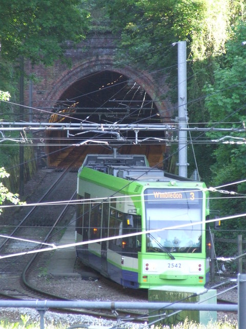
A tram leaving Sandilands tunnel, and taking the sharp left bend to Sandilands tram stop. The tunnel previously carried the Woodside to Sanderstead railway line, which carried straight on here rather than bending sharply to head into Croydon. The railway line closed in 1983, the tram system opened 17 years later. Six years after this photograph was taken, a tram derailed on this curve, resulting in seven deaths and 58 injuries. |
| Date | Taken on 22 May 2010 |
| Source | From geograph.org.uk |
| Author | Malc McDonald |
| Permission (Reusing this file) |
Creative Commons Attribution Share-alike license 2.0 |
| Attribution (required by the license) | Malc McDonald / Sandilands Tunnel / |
| Camera location | | View this and other nearby images on: OpenStreetMap |
|---|
.jpg¶ms=051.374707_N_-000.074721_E_globe:Earth_type:camera_heading:225.00_source:geograph&language=en)
| Object location | | View this and other nearby images on: OpenStreetMap |
|---|
.jpg¶ms=051.373870_N_-000.075700_E_globe:Earth_class:object_type:object_source:geograph-osgb36(TQ34036562)_region:GB-GBN_heading:225.00&language=en)
Licensing

|
This image was taken from the Geograph project collection. See this photograph's page on the Geograph website for the photographer's contact details. The copyright on this image is owned by Malc McDonald and is licensed for reuse under the Creative Commons Attribution-ShareAlike 2.0 license.
|
This file is licensed under the Creative Commons Attribution-Share Alike 2.0 Generic license.
Attribution: Malc McDonald
- You are free:
- to share – to copy, distribute and transmit the work
- to remix – to adapt the work
- Under the following conditions:
- attribution – You must give appropriate credit, provide a link to the license, and indicate if changes were made. You may do so in any reasonable manner, but not in any way that suggests the licensor endorses you or your use.
- share alike – If you remix, transform, or build upon the material, you must distribute your contributions under the same or compatible license as the original.
File history
Click on a date/time to view the file as it appeared at that time.
| Date/Time | Thumbnail | Dimensions | User | Comment | |
|---|---|---|---|---|---|
| current | 11:10, 23 November 2016 | | 480 × 640 (99 KB) | Chris j wood | Transferred from geograph.co.uk using [https://tools.wmflabs.org/geograph2commons/ geograph2commons] |
File usage
The following pages on the English Wikipedia use this file (pages on other projects are not listed):
Global file usage
The following other wikis use this file:
- Usage on fr.wikipedia.org
- Usage on www.wikidata.org
.jpg)