To install click the Add extension button. That's it.

The source code for the WIKI 2 extension is being checked by specialists of the Mozilla Foundation, Google, and Apple. You could also do it yourself at any point in time.

4,5
Kelly Slayton
Congratulations on this excellent venture… what a great idea!
Alexander Grigorievskiy
I use WIKI 2 every day and almost forgot how the original Wikipedia looks like.
Live Statistics
English Articles
Improved in 24 Hours
Added in 24 Hours
What we do. Every page goes through several hundred of perfecting techniques; in live mode. Quite the same Wikipedia. Just better.
.
Leo
Newton
Brights
Milds

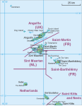
File:SSS Islands Map.png

From Wikipedia, the free encyclopedia

Original file(527 × 678 pixels, file size: 88 KB, MIME type: image/png)

Summary

Description
Map of middle part of Leeward Islands (Anguilla, Saint-Martin/Sint Maarten, Saint-Barthélemy, Saba, Sint Eustatius
Date
Source Own work
Author Hanhil based on File:Saint Martin Map.png by Aotearoa
Other versions

Licensing

I, Hanhil, the copyright holder of this work, hereby publishes it under the following licenses:
GNU head Permission is granted to copy, distribute and/or modify this document under the terms of the GNU Free Documentation License, Version 1.2 or any later version published by the Free Software Foundation; with no Invariant Sections, no Front-Cover Texts, and no Back-Cover Texts. A copy of the license is included in the section entitled GNU Free Documentation License.
w:en:Creative Commons
attribution share alike
This file is licensed under the Creative Commons Attribution-Share Alike 3.0 Unported license.
Attribution: I, Hanhil
You are free:
  • to share – to copy, distribute and transmit the work
  • to remix – to adapt the work
Under the following conditions:
  • attribution – You must give appropriate credit, provide a link to the license, and indicate if changes were made. You may do so in any reasonable manner, but not in any way that suggests the licensor endorses you or your use.
  • share alike – If you remix, transform, or build upon the material, you must distribute your contributions under the same or compatible license as the original.
This licensing tag was added to this file as part of the GFDL licensing update.
You may select the license of your choice.

Captions

Add a one-line explanation of what this file represents

Items portrayed in this file

depicts

17 October 2009

image/png

File history

Click on a date/time to view the file as it appeared at that time.

Date/TimeThumbnailDimensionsUserComment
current09:34, 10 November 2020Thumbnail for version as of 09:34, 10 November 2020527 × 678 (88 KB)HanzlanSaint-Barthélemy instead of Saint-Barthélémy
11:05, 14 April 2013Thumbnail for version as of 11:05, 14 April 2013527 × 678 (68 KB)Edoardo CavaleriPhilipsburg, Sint Maarten capital.
08:38, 22 November 2010Thumbnail for version as of 08:38, 22 November 2010527 × 678 (68 KB)Westeri
22:44, 10 October 2010Thumbnail for version as of 22:44, 10 October 2010527 × 678 (88 KB)Fentener van Vlissingenupdate after dissolution of the Netherlands Antilles
04:43, 17 October 2009Thumbnail for version as of 04:43, 17 October 2009527 × 678 (63 KB)Hanhil{{Information |Description={{nl|Bovenwindse Eilanden (Anguilla, Saint-Martin/Sint Maarten, Saint-Barthélemy, Saba, Sint Eustatius}} {{pl|Mapa środkowej części Wysp Podwietrznych (Anguilla, Saint-Martin/Sint Maarten, Saint-Barthélemy, Saba, Sint Eusta
The following pages on the English Wikipedia use this file (pages on other projects are not listed):

Global file usage

The following other wikis use this file:

View more global usage of this file.

Metadata

Basis of this page is in Wikipedia. Text is available under the CC BY-SA 3.0 Unported License. Non-text media are available under their specified licenses. Wikipedia® is a registered trademark of the Wikimedia Foundation, Inc. WIKI 2 is an independent company and has no affiliation with Wikimedia Foundation.