

Size of this preview: 800 × 322 pixels. Other resolutions: 320 × 129 pixels | 640 × 258 pixels | 1,024 × 413 pixels | 2,000 × 806 pixels.
Original file (2,000 × 806 pixels, file size: 981 KB, MIME type: image/png)
| This is a file from the Wikimedia Commons. Information from its description page there is shown below. Commons is a freely licensed media file repository. You can help. |
Summary
| Description |
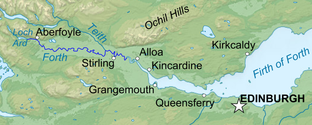
Topographic map in English of Scotland *UTM projection ; WGS84 datum ; shaded relief (composite image of N-W, W and N lightning positions) ;This is a lighter raster JPG format version of Image:Scotland_topographic_map-en.svg which should be used in the article pages, the vector graphics version purpose being for modification and / or translation. *Scales: **Topography and shore/lakes limits: 1:872,000 (accuracy: 218 m) until 60.38° and 1:3,800,000 (accuracy: 950 m) North of 60.38° ; ** Bathymetry: 1:7,588,000 (accuracy: 1,897 m) |
| Date | (UTC) |
| Source |
This file was derived from: Scotland topographic map-en.jpg:  |
| Author |
|
| This is a retouched picture, which means that it has been digitally altered from its original version. Modifications: Isolated the river forth area. The original can be viewed here: Scotland topographic map-en.jpg:
|
Licensing
I, the copyright holder of this work, hereby publish it under the following licenses:
This file is licensed under the Creative Commons Attribution-Share Alike 3.0 Unported, 2.5 Generic, 2.0 Generic and 1.0 Generic license.
- You are free:
- to share – to copy, distribute and transmit the work
- to remix – to adapt the work
- Under the following conditions:
- attribution – You must give appropriate credit, provide a link to the license, and indicate if changes were made. You may do so in any reasonable manner, but not in any way that suggests the licensor endorses you or your use.
- share alike – If you remix, transform, or build upon the material, you must distribute your contributions under the same or compatible license as the original.

|
Permission is granted to copy, distribute and/or modify this document under the terms of the GNU Free Documentation License, Version 1.2 or any later version published by the Free Software Foundation; with no Invariant Sections, no Front-Cover Texts, and no Back-Cover Texts. A copy of the license is included in the section entitled GNU Free Documentation License. |
You may select the license of your choice.
Original upload log
This image is a derivative work of the following images:
- File:Scotland_topographic_map-en.jpg licensed with Cc-by-sa-3.0,2.5,2.0,1.0, GFDL
- 2010-07-17T21:41:29Z Sting 2400x3450 (2398211 Bytes) Color profile
- 2008-09-24T23:35:01Z Sting 2400x3450 (2082807 Bytes) Completely new background : raster topography and using ETOPO1 data for bathymetry ; new standard colors
- 2007-12-14T01:02:41Z Sting 2400x3450 (2224139 Bytes) Additional name
- 2007-12-12T20:55:32Z Sting 2400x3450 (2220337 Bytes) Correction in key
- 2007-12-12T16:18:25Z Sting 2400x3450 (2218854 Bytes) {{Location|57|00|00|N|04|00|00|W|scale:4000000}} {{Information |Description=Topographic map in English of [[:en:Scotland|Scotland]]This is a lighter raster JPG format version of [[:Image:Scotland_topographic_map-en.svg]] whi
Uploaded with derivativeFX
File history
Click on a date/time to view the file as it appeared at that time.
| Date/Time | Thumbnail | Dimensions | User | Comment | |
|---|---|---|---|---|---|
| current | 22:04, 22 January 2013 | 2,000 × 806 (981 KB) | VanguardScot | Added loch ard, highlighted the actual river forth | |
| 21:57, 22 January 2013 | 2,988 × 1,204 (991 KB) | VanguardScot | added grangemouth | ||
| 22:27, 17 January 2013 | 715 × 263 (314 KB) | VanguardScot | == {{int:filedesc}} == {{Information |Description={{en|Topographic map in English of Scotland<br/>This is a lighter raster JPG format version of Image:Scotland_topographic_map-en.svg which should be used in the article pages, the ... |
File usage
The following pages on the English Wikipedia use this file (pages on other projects are not listed):
Global file usage
The following other wikis use this file:
- Usage on ca.wikipedia.org
- Usage on cs.wikipedia.org
- Usage on et.wikipedia.org
- Usage on fa.wikipedia.org
- Usage on fi.wikipedia.org
- Usage on fr.wikipedia.org
- Usage on he.wikipedia.org
- Usage on is.wikipedia.org
- Usage on it.wikipedia.org
- Usage on ja.wikipedia.org
- Usage on no.wikipedia.org
- Usage on sh.wikipedia.org
- Usage on sr.wikipedia.org
- Usage on uk.wikipedia.org