

Size of this PNG preview of this SVG file: 640 × 600 pixels. Other resolutions: 256 × 240 pixels | 819 × 768 pixels | 1,092 × 1,024 pixels | 2,185 × 2,048 pixels | 783 × 734 pixels.
Original file (SVG file, nominally 783 × 734 pixels, file size: 8.21 MB)
| This is a file from the Wikimedia Commons. Information from its description page there is shown below. Commons is a freely licensed media file repository. You can help. |
Summary
| Description |
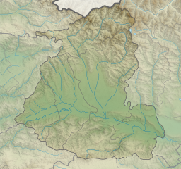
Relief map of Shida Kartli
Mercator projection. Geographic limits of the map:
|
||
| Date | |||
| Source | Own work by the original uploader | ||
| Author | Giorgi Balakhadze at English Wikipedia |


Licensing
Giorgi Balakhadze at English Wikipedia, the copyright holder of this work, hereby publishes it under the following license:
This file is licensed under the Creative Commons Attribution 4.0 International license.
Attribution: Giorgi Balakhadze at English Wikipedia
- You are free:
- to share – to copy, distribute and transmit the work
- to remix – to adapt the work
- Under the following conditions:
- attribution – You must give appropriate credit, provide a link to the license, and indicate if changes were made. You may do so in any reasonable manner, but not in any way that suggests the licensor endorses you or your use.
Original upload log
The original description page was here. All following user names refer to en.wikipedia.
| Date/Time | Dimensions | User | Comment |
|---|---|---|---|
| 2016-06-17 13:29 | 783×734× (8608739 bytes) | Giorgi Balakhadze | fix |
| 2016-06-17 12:40 | 783×734× (8613485 bytes) | Giorgi Balakhadze | {{Copy to Commons|human=Giorgi Balakhadze}} == Summary == {{Information |Description={{en|Relief map of [[:en:Georgia (country)|Georgia]]}} </br>Mercator projection. Geographic limits of the map: * N: 42.65° N * S: 41.68° N * W: 43.31.8° E * E: 44.6... |
File history
Click on a date/time to view the file as it appeared at that time.
| Date/Time | Thumbnail | Dimensions | User | Comment | |
|---|---|---|---|---|---|
| current | 22:30, 15 January 2019 | | 783 × 734 (8.21 MB) | Giorgi Balakhadze | style fix |
| 01:32, 19 June 2016 |  | 783 × 734 (8.21 MB) | OgreBot | (BOT): Reverting to most recent version before archival | |
| 01:32, 19 June 2016 |  | 783 × 734 (8.21 MB) | OgreBot | (BOT): Uploading old version of file from en.wikipedia; originally uploaded on 2016-06-17 12:40:11 by Giorgi Balakhadze | |
| 09:31, 18 June 2016 |  | 783 × 734 (8.21 MB) | কায়সার আহমাদ | Transferred from en.wikipedia |
File usage
The following pages on the English Wikipedia use this file (pages on other projects are not listed):
- Ateni gorge
- Bateti Lake
- Britat
- Geri, Georgia
- Gori, Georgia
- Java (town)
- Kabargin Oth Group
- Kareli, Georgia
- Kaspi
- Keli Highland
- Khashuri
- Khtsisi John the Baptist church
- Kldekari (mountain)
- Liakhvi Strict Nature Reserve
- Likhi Range
- Nabakhtevi Virgin Mary Church
- Samtsevrisi Castle
- Shida Kartli
- Surami
- Tskhinvali
- Tsona Cave
Global file usage
The following other wikis use this file:
- Usage on ar.wikipedia.org
- Usage on az.wikipedia.org
- Usage on de.wikipedia.org
- Usage on eo.wikipedia.org
- Usage on es.wikipedia.org
- Usage on fa.wikipedia.org
- Usage on fr.wikipedia.org
- Usage on he.wikipedia.org
- Usage on mdf.wikipedia.org
- Usage on nl.wikipedia.org
- Usage on os.wikipedia.org
- Usage on ru.wikipedia.org
- Usage on simple.wikipedia.org
- Usage on si.wikipedia.org
- Usage on uk.wikipedia.org
- Usage on uz.wikipedia.org
View more global usage of this file.