To install click the Add extension button. That's it.

The source code for the WIKI 2 extension is being checked by specialists of the Mozilla Foundation, Google, and Apple. You could also do it yourself at any point in time.

4,5
Kelly Slayton
Congratulations on this excellent venture… what a great idea!
Alexander Grigorievskiy
I use WIKI 2 every day and almost forgot how the original Wikipedia looks like.
Live Statistics
English Articles
Improved in 24 Hours
Added in 24 Hours
What we do. Every page goes through several hundred of perfecting techniques; in live mode. Quite the same Wikipedia. Just better.
.
Leo
Newton
Brights
Milds

File:Radar-bright-band.png

From Wikipedia, the free encyclopedia

Radar-bright-band.png(791 × 449 pixels, file size: 263 KB, MIME type: image/png)

Summary

Description
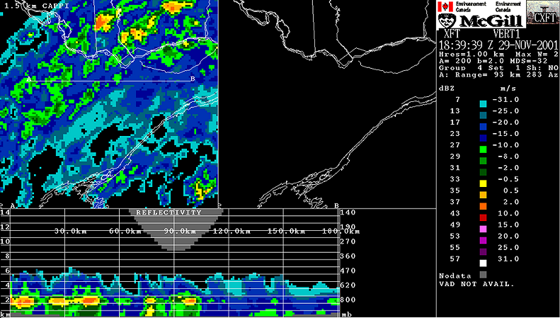
Snow falling through the freezing level will melt and reach the ground as rain. On this image, at the top we can see a CAPPI of precipitations. At the bottom, there is a cross-section of the radar data from ground to 15 km. One can see a level where echos are stronger: the bright-band. The melting begin to occur just above this band and continue until its lower part.

This effect is due to the fact that the reflectivity depend on the 6th power of the diameter of targets multiplied by its ability to reflect. Snow flakes are much larger than rain drops but they reflect much less so echos from snow and rain have intensities relatively close. However, when snow melt, it keeps its diameter for a while and get coated with water. The radar beam sees something similar to a very larger water dropplet and the return is producing this very strong band.
Date 1839 UTC
Source
English: Meteorological Service of Canada (Environment Canada). Redistribution allowed if source mentionned
Author
Français : Ce radar est opéré par Environnement Canada. La sortie radar est produite par le logiciel développé par l'Observatoire radar J.S. Marshall de l'Université McGill en collaboration avec EC.

Licensing

© The copyright holder of this file allows anyone to use it for any purpose, provided that the copyright holder is properly attributed. Redistribution, derivative work, commercial use, and all other use is permitted.

Captions

Add a one-line explanation of what this file represents

Items portrayed in this file

depicts

File history

Click on a date/time to view the file as it appeared at that time.

Date/TimeThumbnailDimensionsUserComment
current15:20, 8 May 2006Thumbnail for version as of 15:20, 8 May 2006791 × 449 (263 KB)Pierre cbSnow falling through the freezing level will melt and reach the ground as rain. On this image, at the top we can see a CAPPI of precipitations. At the bottom, there is a cross-section of the radar data from ground to 15 km. On can see a level where echos
The following pages on the English Wikipedia use this file (pages on other projects are not listed):

Global file usage

The following other wikis use this file:

Basis of this page is in Wikipedia. Text is available under the CC BY-SA 3.0 Unported License. Non-text media are available under their specified licenses. Wikipedia® is a registered trademark of the Wikimedia Foundation, Inc. WIKI 2 is an independent company and has no affiliation with Wikimedia Foundation.