

Size of this preview: 600 × 600 pixels. Other resolutions: 240 × 240 pixels | 480 × 480 pixels | 768 × 768 pixels | 1,024 × 1,024 pixels | 2,048 × 2,048 pixels | 3,009 × 3,009 pixels.
Original file (3,009 × 3,009 pixels, file size: 2.15 MB, MIME type: image/png)
| This is a file from the Wikimedia Commons. Information from its description page there is shown below. Commons is a freely licensed media file repository. You can help. |
Summary
| Description |
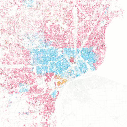
Race and ethnicity in Detroit, Michigan White African-American Asian Hispanic Other Each dot is 25 people. |
| Date | |
| Source |
Race and ethnicity: Detroit on Flickr Data from Census 2000, base map from OpenStreetMap Uploaded by Imzadi1979 |
| Author | Eric Fischer |
| Camera location | | View this and other nearby images on: OpenStreetMap |
|---|
Licensing
This file is licensed under the Creative Commons Attribution-Share Alike 2.0 Generic license.
- You are free:
- to share – to copy, distribute and transmit the work
- to remix – to adapt the work
- Under the following conditions:
- attribution – You must give appropriate credit, provide a link to the license, and indicate if changes were made. You may do so in any reasonable manner, but not in any way that suggests the licensor endorses you or your use.
- share alike – If you remix, transform, or build upon the material, you must distribute your contributions under the same or compatible license as the original.
| This image, originally posted to Flickr, was reviewed on September 24, 2010 by the administrator or reviewer File Upload Bot (Magnus Manske), who confirmed that it was available on Flickr under the stated license on that date. |
File history
Click on a date/time to view the file as it appeared at that time.
| Date/Time | Thumbnail | Dimensions | User | Comment | |
|---|---|---|---|---|---|
| current | 06:50, 2 March 2013 | | 3,009 × 3,009 (2.15 MB) | JohnnyMrNinja | index colors and increase compression |
| 12:15, 24 September 2010 |  | 3,009 × 3,009 (5.91 MB) | File Upload Bot (Magnus Manske) | {{Information |Description=I was astounded by [http://www.radicalcartography.net/index.html?chicagodots Bill Rankin's map of Chicago's racial and ethnic divides] and wanted to see what other cities looked like mapped the same way. To match his map, Red i |
File usage
The following pages on the English Wikipedia use this file (pages on other projects are not listed):
Global file usage
The following other wikis use this file:
- Usage on de.wikipedia.org
- Usage on he.wikivoyage.org
- Usage on te.wikipedia.org
- Usage on www.wikidata.org