
![Queens, Vol. 1, Double Page Plate No. 35; Part of Ward 5; Rockaway; [Map bounded by Jamaica Bay, Charmttoir Island, Mc. Caffertys Island, Nortons Creek, Hudson Ave., Columbus Ave., Rochester Ave., Wave Crest Ave., Surf Ave., Grand-View Ave., Beach Ave.; Including Ocean Ave., Neptune Ave., Sea Gate Ave., Sea-View Ave., Florence Ave., Lucia Ave., Storm Ave., Straiton Ave., Jerome Ave., Alexander Ave., Bouker Ave., Amstel Canal.]; Sub Plan; [Map bounded by Fulton Ave., Dickerson Ave.; Including Hudson Ave., Columbus Ave.]; Atlases of New York city. / Atlas of the borough of Queens, city of New York : based upon official plans and maps on file in the various city offices; supplemented by careful field measurements and personal observations / by and under the supervision of Hugo Ullitz. / Fourth and fifth wards: Jamaica and Rockaway.](http://upload.wikimedia.org/wikipedia/commons/thumb/8/8c/Queens%2C_Vol._1%2C_Double_Page_Plate_No._35%3B_Part_of_Ward_5%3B_Rockaway%3B_%28Map_bounded_by_Jamaica_Bay%2C_Charmttoir_Island%2C_Mc._Caffertys_Island%2C_Nortons_Creek%2C_Hudson_Ave.%2C_Columbus_Ave.%2C_Rochester_NYPL1693878.tiff/lossy-page1-800px-thumbnail.tiff.jpg)
Size of this JPG preview of this TIF file: 800 × 593 pixels. Other resolutions: 320 × 237 pixels | 640 × 474 pixels | 1,024 × 759 pixels | 1,280 × 948 pixels | 2,560 × 1,897 pixels | 6,888 × 5,104 pixels.
Original file (6,888 × 5,104 pixels, file size: 100.59 MB, MIME type: image/tiff)
| This is a file from the Wikimedia Commons. Information from its description page there is shown below. Commons is a freely licensed media file repository. You can help. |
Summary
| Description | Queens, Vol. 1, Double Page Plate No. 35; Part of Ward 5; Rockaway; [Map bounded by Jamaica Bay, Charmttoir Island, Mc. Caffertys Island, Nortons Creek, Hudson Ave., Columbus Ave., Rochester Ave., Wave Crest Ave., Surf Ave., Grand-View Ave., Beach Ave.; Including Ocean Ave., Neptune Ave., Sea Gate Ave., Sea-View Ave., Florence Ave., Lucia Ave., Storm Ave., Straiton Ave., Jerome Ave., Alexander Ave., Bouker Ave., Amstel Canal.]; Sub Plan; [Map bounded by Fulton Ave., Dickerson Ave.; Including Hudson Ave., Columbus Ave.]; Atlases of New York city. / Atlas of the borough of Queens, city of New York : based upon official plans and maps on file in the various city offices; supplemented by careful field measurements and personal observations / by and under the supervision of Hugo Ullitz. / Fourth and fifth wards: Jamaica and Rockaway. | |||||||||||||||||||||||
| Catalogue call number | Map Div.+++ (Queens, New York. 1912-1913) (Hyde, E.B., Map Co., Inc. Atlas of the borough of Queens) | |||||||||||||||||||||||
| Item/Page/Plate | 35 | |||||||||||||||||||||||
| Date | between 1907 and 1908 | |||||||||||||||||||||||
| Source |
http://digitalgallery.nypl.org/nypldigital/dgkeysearchdetail.cfm?imageID=1693878
|
|||||||||||||||||||||||
| Author | ||||||||||||||||||||||||
| Permission (Reusing this file) |
From The Lionel Pincus and Princess Firyal Map Division. http://maps.nypl.org
|
|||||||||||||||||||||||
| Location | Stephen A. Schwarzman Building / The Lionel Pincus and Princess Firyal Map Division | |||||||||||||||||||||||
| Digital item published | 2-27-2009; updated 3-25-2011 | |||||||||||||||||||||||
| Digital ID | 1693878 | |||||||||||||||||||||||

The making of this file was supported by Wikimedia UK.
To see other files made with the support of Wikimedia UK, please see the category Supported by Wikimedia UK.
|
File history
Click on a date/time to view the file as it appeared at that time.
| Date/Time | Thumbnail | Dimensions | User | Comment | |
|---|---|---|---|---|---|
| current | 15:18, 8 May 2014 | 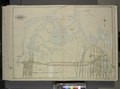 | 6,888 × 5,104 (100.59 MB) | Fæ | GWToolset: Creating mediafile for Fæ. Tranche 4 -4989 restart @08:55 BST, 7 May 2014 |
File usage
The following pages on the English Wikipedia use this file (pages on other projects are not listed):