

Size of this preview: 800 × 600 pixels. Other resolutions: 320 × 240 pixels | 640 × 480 pixels | 1,024 × 768 pixels | 1,280 × 960 pixels | 2,560 × 1,920 pixels | 2,816 × 2,112 pixels.
Original file (2,816 × 2,112 pixels, file size: 2.32 MB, MIME type: image/jpeg)
| This is a file from the Wikimedia Commons. Information from its description page there is shown below. Commons is a freely licensed media file repository. You can help. |
|
This is an image of a place or building that is listed on the National Register of Historic Places in the United States of America. Its reference number is 75001511. |
| Camera location | | View this and other nearby images on: OpenStreetMap |
|---|
| Description |
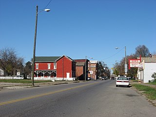
Northward along Putnam Avenue (U.S. Route 22) between its intersections with Van Buren and Madison Streets in southern Zanesville, Ohio, United States. The neighborhood pictured is part of the Putnam Historic District, a historic district that is listed on the National Register of Historic Places. |
||
| Date | Taken on 12 November 2009 | ||
| Source | Own work | ||
| Author | Nyttend | ||
| Permission (Reusing this file) |
|
File history
Click on a date/time to view the file as it appeared at that time.
| Date/Time | Thumbnail | Dimensions | User | Comment | |
|---|---|---|---|---|---|
| current | 14:42, 20 November 2009 | | 2,816 × 2,112 (2.32 MB) | Nyttend | {{Location|39|55|44.4|N|82|0|25.2|W}} {{Information |Description={{en|Northward along Putnam Avenue ({{w|U.S. Route 22}) between its intersections with Van Buren and Madison Streets in southern {{w|Zanesville, Ohio|Zanesville}}, {{w|Ohio}}, {{w|United Sta |
File usage
The following pages on the English Wikipedia use this file (pages on other projects are not listed):