
Size of this preview: 600 × 600 pixels. Other resolutions: 240 × 240 pixels | 480 × 480 pixels | 768 × 768 pixels | 1,024 × 1,024 pixels | 2,048 × 2,048 pixels | 5,160 × 5,160 pixels.
Original file (5,160 × 5,160 pixels, file size: 2.84 MB, MIME type: image/png)
| This is a file from the Wikimedia Commons. Information from its description page there is shown below. Commons is a freely licensed media file repository. You can help. |
Summary
| Description |
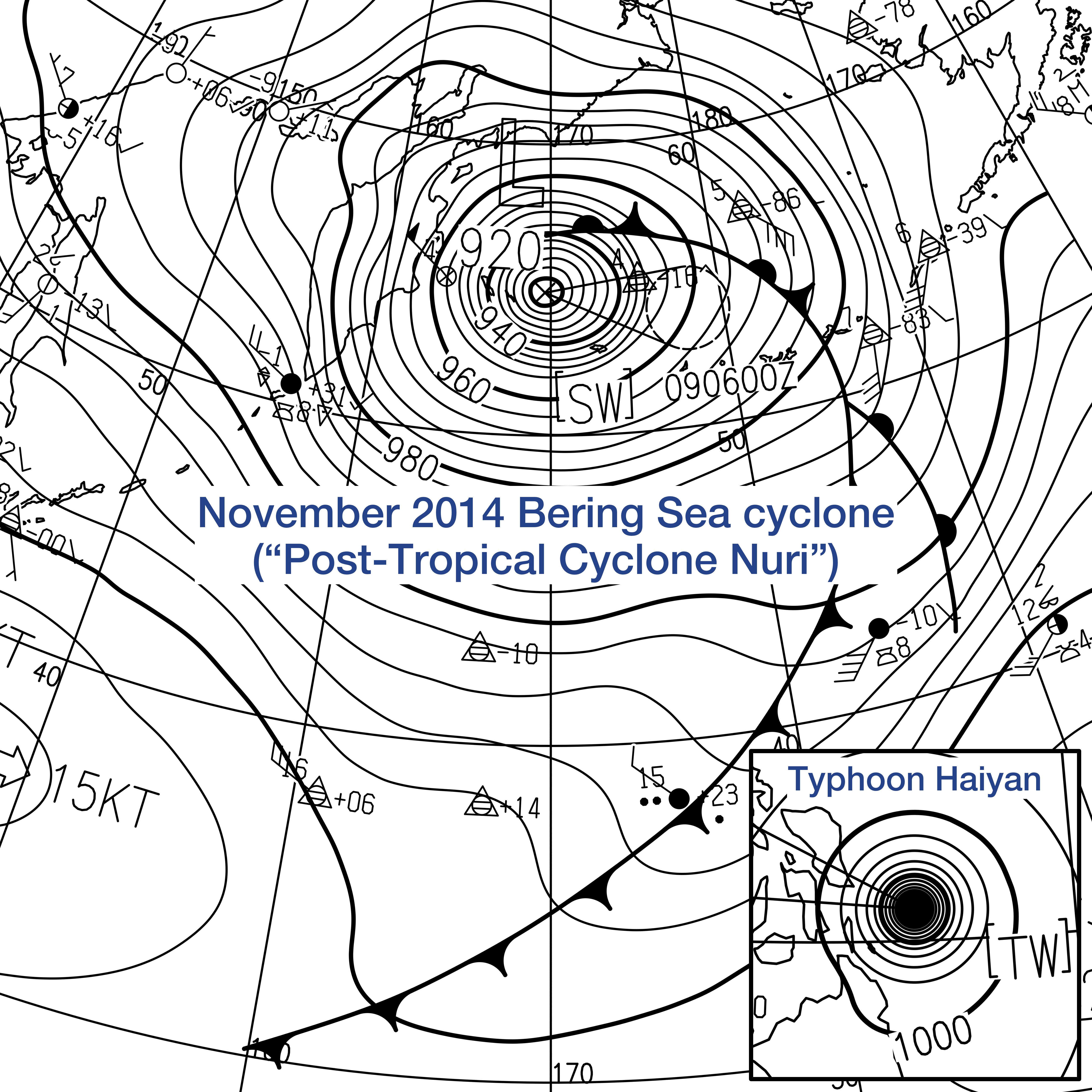
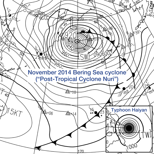
This is a comparison between one of the most intense extratropical cyclones and one of the most intense tropical cyclones in history, on different weather surface maps provided by the Japan Meteorological Agency. Extratropical cyclones are generally much larger but looser than tropical cyclones.
The much larger system is an extratropical cyclone over the Bering Sea at 18:00 Kamchatka Time (06:00 Coordinated Universal Time) on November 8, 2014, also widely known as Post-Tropical Cyclone Nuri. According to the JMA, the central pressure was 920 hPa, and 10-minute maximum sustained winds were 70 knots. The extratropical cyclone is the cause of a North American cold wave in November 2014. The much smaller system is Typhoon Haiyan approaching the Philippines at 02:00 Philippine Standard Time on November 8, 2013 (at 18:00 Coordinated Universal Time on November 7), also known as Super Typhoon Yolanda locally. According to the JMA, the central pressure was 895 hPa, and 10-minute maximum sustained winds were 125 knots. Typhoon Haiyan killed 6,300 people in the Philippines in November 2013. |
| Date | |
| Source | http://www.jma.go.jp/jp/g3/images/asia/pdf/asas.pdf |
| Author | Japan Meteorological Agency |
Licensing
This image was produced by the Japan Meteorological Agency. The legal notice (archive) stated that all the images published on their website is compatible with the Creative Commons Attribution 4.0 License, which means that all the images on this website is published under the Creative Commons Attribution 4.0 License unless otherwise specified.
This file is licensed under the Creative Commons Attribution 4.0 International license. Attribution: Japan Meteorological Agency
|
 |

File history
Click on a date/time to view the file as it appeared at that time.
| Date/Time | Thumbnail | Dimensions | User | Comment | |
|---|---|---|---|---|---|
| current | 02:09, 3 June 2016 | | 5,160 × 5,160 (2.84 MB) | Meow | User created page with UploadWizard |
File usage
The following pages on the English Wikipedia use this file (pages on other projects are not listed):
Global file usage
The following other wikis use this file: