

Size of this PNG preview of this SVG file: 412 × 599 pixels. Other resolutions: 165 × 240 pixels | 330 × 480 pixels | 528 × 768 pixels | 704 × 1,024 pixels | 1,409 × 2,048 pixels | 4,200 × 6,105 pixels.
Original file (SVG file, nominally 4,200 × 6,105 pixels, file size: 2.97 MB)
| This is a file from the Wikimedia Commons. Information from its description page there is shown below. Commons is a freely licensed media file repository. You can help. |
Summary
| Description |
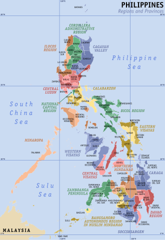
Map of the Philippines showing the location of all the regions and provinces.
Notes: The map does not depict cities that are independent of any province. It also does not depict the status of Sabah, the Spratly Islands, and Scarborough Shoal as disputed Philippine territories. |
| Date | |
| Source | Own work, based on seav's Ph regions and provinces.png and Felipe Aira's File:PhlMapCit.svg |
| Author | HueMan1 |
| Other versions |
|

Licensing
HueMan1, the copyright holder of this work, hereby publishes it under the following license:

|
Permission is granted to copy, distribute and/or modify this document under the terms of the GNU Free Documentation License, Version 1.2 or any later version published by the Free Software Foundation; with no Invariant Sections, no Front-Cover Texts, and no Back-Cover Texts. A copy of the license is included in the section entitled GNU Free Documentation License. |
File history
Click on a date/time to view the file as it appeared at that time.
| Date/Time | Thumbnail | Dimensions | User | Comment | |
|---|---|---|---|---|---|
| current | 05:49, 23 July 2023 | | 4,200 × 6,105 (2.97 MB) | Hariboneagle927 | + Maguindanao division |
| 23:58, 11 March 2023 |  | 4,200 × 6,105 (2.95 MB) | Hariboneagle927 | Bangsamoro SGA in Cotabato (since Lamitan is shown as part of Zamboanga Peninsula in this map) | |
| 15:58, 10 December 2019 |  | 4,200 × 6,105 (2.94 MB) | HueMan1 | Renamed Compostela Valley to Davao de Oro. | |
| 05:09, 9 August 2019 |  | 4,200 × 6,105 (2.95 MB) | HueMan1 | Minor fixes | |
| 12:26, 19 July 2019 |  | 4,200 × 6,105 (2.95 MB) | HueMan1 | Minor fixes | |
| 10:10, 1 July 2019 |  | 4,200 × 6,105 (2.95 MB) | HueMan1 | User created page with UploadWizard |
File usage
The following pages on the English Wikipedia use this file (pages on other projects are not listed):
- Administrative divisions of the Philippines
- Autonomous Region in Muslim Mindanao
- Autonomous regions of the Philippines
- Bangsamoro
- Barangay
- Barangay captain
- Barangay elections
- Barangay hall
- Caburacanan
- Cities of the Philippines
- Internal Revenue Allotment
- Kalayaan, Palawan
- Lanao del Sur
- Legislative districts of the Philippines
- List of cities and municipalities in the Philippines
- List of primary local government units of the Philippines
- Luzon
- Maguindanao del Norte
- Maguindanao del Sur
- Manila
- Metro Manila
- Mindanao
- Municipalities of the Philippines
- Negros
- Negros Island Region
- Outline of the Philippines
- Partido (historical province)
- Philippines
- Provinces of the Philippines
- Quezon City
- Regions of the Philippines
- Southern Tagalog
- Special Geographic Area
- Spratly Islands
- Sub-provinces of the Philippines
- Territories claimed by the Philippines
- Valenzuela, Metro Manila
- Visayas
Global file usage
The following other wikis use this file:
- Usage on an.wikipedia.org
- Usage on bcl.wikipedia.org
- Usage on be-tarask.wikipedia.org
- Usage on el.wikipedia.org
- Usage on ka.wikipedia.org
- მინდანაო
- ლუსონი
- ლაგუნის პროვინცია
- ვისაიასი
- ფილიპინების ადმინისტრაციული დაყოფა
- თარგი:ფილიპინების ადმინისტრაციული დაყოფა
- სებუს პროვინცია
- კატანდუანესი
- პანგასინანი
- კულიონი
- ბილირანი
- ლა-უნიონის პროვინცია (ფილიპინები)
- აბრის პროვინცია
- დავაოს რეგიონი
- პაგადიანი
- ბატანესი
- ზამბოანგის ნახევარკუნძული
- კორდილიერის ადმინისტრაციული რეგიონი
- ბიკოლის რეგიონი
- აღმოსავლეთი ვისაიასი
- ბანგსამორო
- ავტონომიური რეგიონი მუსლიმურ მინდანაოში
- კარაგა
- კალაბარსონი
- ფილიპინების ქალაქები
- ფილიპინების პროვინციები
- ბარანგაი
- თარგი:ფილიპინების რეგიონები
- ეროვნული დედაქალაქის რეგიონი
- მიმაროპა
- მარინდუკე
- ფილიპინების რეგიონები
- რომბლონი
- ადგილობრივი მმართველობა ფილიპინებში
- კაგაიანის ხეობა
- ისაბელას პროვინცია
- ნუევა-ვისკაია
- ალბაის პროვინცია
- აპაიაო
- ილაგანი
- კაგაიანი
- აურორას პროვინცია
- ბენგეტი
- ბუკიდნონის პროვინცია
- კოტაბატოს პროვინცია
- ბულაკანი
View more global usage of this file.