

Size of this preview: 800 × 450 pixels. Other resolutions: 320 × 180 pixels | 640 × 360 pixels | 1,024 × 576 pixels | 1,280 × 720 pixels | 2,016 × 1,134 pixels.
Original file (2,016 × 1,134 pixels, file size: 1.01 MB, MIME type: image/jpeg)
| This is a file from the Wikimedia Commons. Information from its description page there is shown below. Commons is a freely licensed media file repository. You can help. |
Summary
| Description |
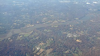
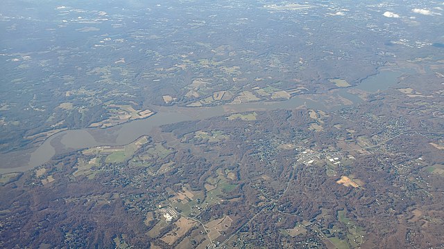
Oblique air photo looking east of the Patuxent River flowing from upper right to lower left across southern Maryland. Chaneyville is at bottom center, and Dunkirk is above and to the right of it. Both are on MD Route 4 in Calvert County. Croom and Marlton are visible on the far side of the river in Prince George's County. Joint Base Andrews is in the upper right. |
| Date | Taken on 9 November 2020, 13:44:59 |
| Source | Own work |
| Author | Jstuby |
| Camera location | | View this and other nearby images on: OpenStreetMap |
|---|
Licensing
I, the copyright holder of this work, hereby publish it under the following license:
| This file is made available under the Creative Commons CC0 1.0 Universal Public Domain Dedication. | |
| The person who associated a work with this deed has dedicated the work to the public domain by waiving all of their rights to the work worldwide under copyright law, including all related and neighboring rights, to the extent allowed by law. You can copy, modify, distribute and perform the work, even for commercial purposes, all without asking permission.
|
| Annotations | This image is annotated: View the annotations at Commons |
File history
Click on a date/time to view the file as it appeared at that time.
| Date/Time | Thumbnail | Dimensions | User | Comment | |
|---|---|---|---|---|---|
| current | 04:07, 13 November 2020 | | 2,016 × 1,134 (1.01 MB) | Jstuby | Uploaded own work with UploadWizard |
File usage
The following pages on the English Wikipedia use this file (pages on other projects are not listed):
Global file usage
The following other wikis use this file:
- Usage on pt.wikipedia.org