
Size of this preview: 800 × 474 pixels. Other resolutions: 320 × 190 pixels | 640 × 379 pixels | 1,053 × 624 pixels.
Original file (1,053 × 624 pixels, file size: 20 KB, MIME type: image/png)
| This is a file from the Wikimedia Commons. Information from its description page there is shown below. Commons is a freely licensed media file repository. You can help. |

|
This locator map image could be re-created using vector graphics as an SVG file. This has several advantages; see Commons:Media for cleanup for more information. If an SVG form of this image is available, please upload it and afterwards replace this template with
{{vector version available|new image name}}.
It is recommended to name the SVG file “Okresy ČR 2007.svg”—then the template Vector version available (or Vva) does not need the new image name parameter. |
Summary
| Description |
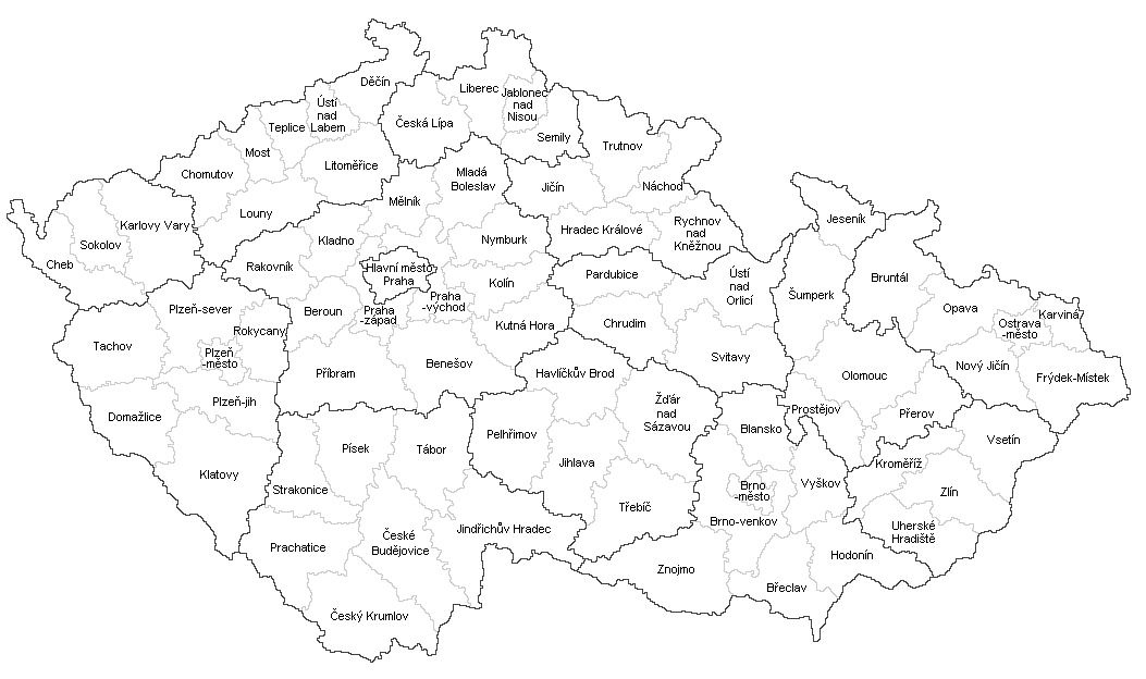
Czech districts in autonomous regions (constitutional Law No. 347/1997 Coll.) with current borders since January 1, 2007. |
| Date | |
| Source | Own work |
| Author | Mapového náložník |
| Other versions |
|
Licensing
| I, the copyright holder of this work, release this work into the public domain. This applies worldwide. In some countries this may not be legally possible; if so: I grant anyone the right to use this work for any purpose, without any conditions, unless such conditions are required by law. |
File history
Click on a date/time to view the file as it appeared at that time.
| Date/Time | Thumbnail | Dimensions | User | Comment | |
|---|---|---|---|---|---|
| current | 20:05, 30 July 2017 | | 1,053 × 624 (20 KB) | Avayak | optimalizována velikost souboru (40 % původní velikosti) |
| 10:52, 3 January 2016 |  | 1,053 × 624 (49 KB) | Valdemar | white | |
| 20:32, 2 January 2016 |  | 1,053 × 624 (50 KB) | Valdemar | new borders (law no. 15/2015 Coll.) | |
| 23:17, 18 May 2013 |  | 1,053 × 624 (61 KB) | Fext | Oprava názvů městských okresů a Hl. m. Prahy | |
| 15:27, 1 February 2013 |  | 1,053 × 624 (63 KB) | Fext | Zpřehlednění | |
| 07:40, 6 May 2010 |  | 1,053 × 624 (55 KB) | Mapového náložník | Grafické vylepšení | |
| 16:14, 4 May 2010 |  | 1,045 × 613 (54 KB) | Mapového náložník | {{Information |Description={{en|1=Czech districts after 2007}} {{cs|1=Okresy v České republice po roce 2007}} |Source={{own}} |Author=Mapového náložník |Date=4.5.2010 |Permission= |other_versions= }} [[Category:Maps o |
File usage
The following pages on the English Wikipedia use this file (pages on other projects are not listed):
Global file usage
The following other wikis use this file:
- Usage on af.wikipedia.org
- Usage on az.wikipedia.org
- Usage on bg.wikipedia.org
- Usage on bn.wikipedia.org
- Usage on cs.wikipedia.org
- Usage on de.wikipedia.org
- Usage on km.wikipedia.org
- Usage on mn.wikipedia.org
- Usage on pl.wikipedia.org
- Usage on ro.wikipedia.org
- Usage on ru.wikipedia.org
- Usage on sh.wikipedia.org
- Usage on sk.wikipedia.org
- Usage on sr.wikipedia.org
- Usage on test2.wikipedia.org
- Usage on tr.wikipedia.org
- Usage on www.wikidata.org
- Usage on zh-yue.wikipedia.org
- Usage on zh.wikipedia.org