

Original file (3,508 × 2,479 pixels, file size: 215 KB, MIME type: image/png)
| This is a file from the Wikimedia Commons. Information from its description page there is shown below. Commons is a freely licensed media file repository. You can help. |
| Description |
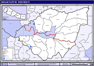
Map displaying Village Development Committees in Bhaktapur District, Nepal |
|||
| Date | ||||
| Source | http://www.un.org.np/maps/district-maps/central/Bhaktapur.pdf | |||
| Author | United Nations | |||
| Permission (Reusing this file) |
|

File history
Click on a date/time to view the file as it appeared at that time.
| Date/Time | Thumbnail | Dimensions | User | Comment | |
|---|---|---|---|---|---|
| current | 01:48, 6 November 2008 | | 3,508 × 2,479 (215 KB) | Sadalmelik | {{Information |Description={{en|1=Map displaying Village Development Committees in Bhaktapur District, Nepal}} |Source=http://www.un.org.np/maps/district-maps/central/Bhaktapur.pdf |Date=January 4, 2008 |Author=United Nations |Permission={{PD-UN}} |ot |
File usage
Global file usage
The following other wikis use this file:
- Usage on de.wikipedia.org
- Usage on fi.wikipedia.org
- Usage on mai.wikipedia.org
- Usage on ms.wikipedia.org
- Usage on ne.wikipedia.org
- भक्तपुर जिल्ला
- चाँगुनारायण गाविस
- बालकोट
- गाउँ विकास समिति (नेपाल)
- ढाँचा:भक्तपुर जिल्लाका गाविसहरू
- कटुञ्जे
- गुण्डु
- चाँगुनारायण नगरपालिका
- चित्तपोल
- छालिङ
- झौखेल
- ताथली
- दधिकोट
- दुवाकोट
- नखेल
- बागेश्वरी, भक्तपुर
- सिपाडोल
- सिरुटार
- सुडाल
- भक्तपुर नगरपालिका
- अनन्तलिङ्गेश्वर नगरपालिका
- सूर्यविनायक नगरपालिका
- महामञ्जुश्री-नगरकोट नगरपालिका
- Usage on nl.wikipedia.org
- Usage on ru.wikipedia.org
- Usage on www.wikidata.org