
NYTMap2ndBattleOfYpres1915.png (480 × 571 pixels, file size: 69 KB, MIME type: image/png)
| This is a file from the Wikimedia Commons. Information from its description page there is shown below. Commons is a freely licensed media file repository. You can help. |
| Description |
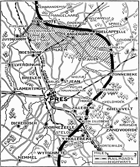
"Current History" (New York Times) map showing reported positions during the Second Battle of Ypres, as at about 30 April 1915. On 1 May the British withdrew to shorten their lines, with the final front line running through Hooge, Frenzenberg (not shown, but 1 3/4 mile sw of Zonnebeke) and west to Mouse Trap farm and Turco farms (not shown, but 1 mile sw of St Julien).
NYT caption : "The German rush across the Yser-Ypres Canal was checked at Lizerne and opposite Boesinghe. The shaded area on the map marks the scene of the battle. Within this area are Steenstraate, Het Sast, Pilkem, St. Julien, and Langemarck, all of which the Germans claimed to have captured." |
| Date | |
| Source |
New York Times Current History. The European War, Vol. 2 No. 3, June 1915. Downloaded from http://www.gutenberg.org/ebooks/15480 |
| Author | "Current History" (New York Times) |
This media file is in the public domain in the United States. This applies to U.S. works where the copyright has expired, often because its first publication occurred prior to January 1, 1929, and if not then due to lack of notice or renewal. See this page for further explanation.
|
 | |
 |
This image might not be in the public domain outside of the United States; this especially applies in the countries and areas that do not apply the rule of the shorter term for US works, such as Canada, Mainland China (not Hong Kong or Macao), Germany, Mexico, and Switzerland. The creator and year of publication are essential information and must be provided. See Wikipedia:Public domain and Wikipedia:Copyrights for more details.
|
File history
Click on a date/time to view the file as it appeared at that time.
| Date/Time | Thumbnail | Dimensions | User | Comment | |
|---|---|---|---|---|---|
| current | 10:26, 13 February 2008 | | 480 × 571 (69 KB) | Rcbutcher | {{Information |Description=New York Times map showing reported positions after the Second Battle of Ypres, April - May 1915. <br>NYT caption : "The German rush across the Yser-Ypres Canal was checked at Lizerne and opposite Boesinghe. The shaded area on t |
File usage
Global file usage
The following other wikis use this file:
- Usage on de.wikipedia.org
- Usage on es.wikipedia.org
- Usage on fr.wikipedia.org
- Usage on he.wikipedia.org
- Usage on it.wikipedia.org
- Usage on nl.wikipedia.org