

Size of this PNG preview of this SVG file: 800 × 409 pixels. Other resolutions: 320 × 164 pixels | 640 × 327 pixels | 1,024 × 524 pixels | 1,280 × 655 pixels | 2,560 × 1,310 pixels | 1,198 × 613 pixels.
Original file (SVG file, nominally 1,198 × 613 pixels, file size: 682 KB)
| This is a file from the Wikimedia Commons. Information from its description page there is shown below. Commons is a freely licensed media file repository. You can help. |
Summary
| Description |
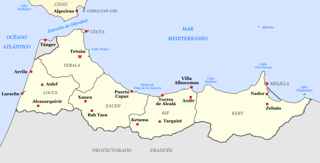
Español: A pocos kilómetros de Alhucemas se encuentra la ciudad de Axdir/Ajdir patria de Abdelkrim |
| Date | 23 February 2006 (original upload date) |
| Source | No machine-readable source provided. Own work assumed (based on copyright claims). |
| Author | No machine-readable author provided. Haylli assumed (based on copyright claims). |
es
- Territorios septentrionales del Protectorado Español de Marruecos (nótese la falta de los territorios meridionales) tal como eran en febrero de 1955, en vísperas de la independencia de Marruecos.
- Producido por Haylli en febrero de 2006 usando Inkscape
Other versions
 |
File:Morocco-spanish-protectorate-1955-a.png
|
Licensing
I, the copyright holder of this work, hereby publish it under the following license:
This file is licensed under the Creative Commons Attribution-Share Alike 2.5 Generic license.
- You are free:
- to share – to copy, distribute and transmit the work
- to remix – to adapt the work
- Under the following conditions:
- attribution – You must give appropriate credit, provide a link to the license, and indicate if changes were made. You may do so in any reasonable manner, but not in any way that suggests the licensor endorses you or your use.
- share alike – If you remix, transform, or build upon the material, you must distribute your contributions under the same or compatible license as the original.
File history
Click on a date/time to view the file as it appeared at that time.
| Date/Time | Thumbnail | Dimensions | User | Comment | |
|---|---|---|---|---|---|
| current | 19:18, 6 February 2011 | | 1,198 × 613 (682 KB) | Tyk | Internal and Ceuta and Melilla borders. |
| 20:40, 21 June 2010 |  | 1,757 × 747 (54 KB) | Ilmari Karonen | Reverted to version as of 15:31, 6 March 2006 (latest version that's actually SVG) | |
| 10:20, 28 February 2010 |  | 799 × 340 (797 KB) | Hpyounes | using another colors | |
| 15:31, 6 March 2006 |  | 1,757 × 747 (54 KB) | Haylli | uploading corrected map | |
| 18:07, 23 February 2006 |  | 744 × 455 (39 KB) | Haylli | ==es== * Territorios septentrionales del Protectorado Español de Marruecos (nótese la falta de los territorios meridionales) * Producido por User:Haylli en febrero de 2006 usando Inkscape |
File usage
The following pages on the English Wikipedia use this file (pages on other projects are not listed):
Global file usage
The following other wikis use this file:
- Usage on ar.wikipedia.org
- الحماية الإسبانية على المغرب
- إسبانيول طنجة
- نادي قصبة طنجة
- النادي القصري
- نادي خوبنتود ماريتيما
- نادي بيسكادورس
- نادي خوبنتود ماروكي
- نادي باطروناطو العرائش
- نادي العرائش الرياضي
- نادي فيلا الناضور
- نادي طنجة فاس
- نادي أتلتيكو أصيلة
- نادي ديبورتيفو بني انصار
- نادي لاس نافاس
- نادي أتلتيكو ليكسوس
- جيش إفريقيا الإسباني
- نادي أطلس طنجة
- انقلاب يوليو 1936 في إسبانيا
- تمرد مليلية العسكري 1936
- Usage on ast.wikipedia.org
- Usage on be.wikipedia.org
- Usage on bg.wikipedia.org
- Usage on br.wikipedia.org
- Usage on ca.wikipedia.org
- Usage on cs.wikipedia.org
- Usage on da.wikipedia.org
- Usage on de.wikipedia.org
- Usage on el.wikipedia.org
- Usage on eo.wikipedia.org
- Usage on es.wikipedia.org
- Usuario:Haylli/Imágenes
- Protectorado español de Marruecos
- Golpe de Estado en España de julio de 1936
- Club Atlético de Tetuán
- Archidiócesis de Tánger
- Ejército de África (España)
- Francisca de Orleans
- Organización territorial del Ejército español en 1936
- Real Federación de Fútbol de Ceuta
- Sublevación militar del 17 de julio de 1936 en Melilla
View more global usage of this file.