

Size of this PNG preview of this SVG file: 800 × 422 pixels. Other resolutions: 320 × 169 pixels | 640 × 337 pixels | 1,024 × 540 pixels | 1,280 × 675 pixels | 2,560 × 1,350 pixels | 2,731 × 1,440 pixels.
Original file (SVG file, nominally 2,731 × 1,440 pixels, file size: 3.97 MB)
| This is a file from the Wikimedia Commons. Information from its description page there is shown below. Commons is a freely licensed media file repository. You can help. |
Summary
| Description |
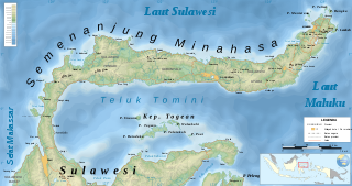
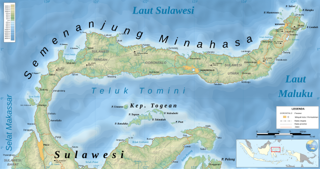
English: Topographic map of the Minahassa Peninsula
Bahasa Indonesia: Peta topografi Semenanjung Minahasa
Русский: Топографическая карта индонезийского полуострова Минахаса. |
|||||||||
| Date | 15 December 2016 (original); 29 December 2017 (this Indonesian translation) | |||||||||
| Source | Own work (Original text: Own translation from File:Minahassa Peninsula topographic map - ru.svg by Kaidor (CC BY SA 4.0) with some toponyms from GeoNames (CC BY 4.0)) | |||||||||
| Creator |
Kaidor (original); Sersan Mayor Kururu (this Indonesian translation) |
|||||||||
| Geotemporal data | ||||||||||
| Spatial reference system | Mercator, WGS84 datum | |||||||||
| Bounding box |
|
|||||||||
| Georeferencing | If inappropriate please set warp_status = skip to hide. | |||||||||
| Other versions |
|
|||||||||
| SVG development | ||||||||||

Licensing
Kaidor (original); Sersan Mayor Kururu (this Indonesian translation), the copyright holder of this work, hereby publishes it under the following license:
This file is licensed under the Creative Commons Attribution-Share Alike 4.0 International license.
Attribution: Kaidor (original); Sersan Mayor Kururu (this Indonesian translation)
- You are free:
- to share – to copy, distribute and transmit the work
- to remix – to adapt the work
- Under the following conditions:
- attribution – You must give appropriate credit, provide a link to the license, and indicate if changes were made. You may do so in any reasonable manner, but not in any way that suggests the licensor endorses you or your use.
- share alike – If you remix, transform, or build upon the material, you must distribute your contributions under the same or compatible license as the original.
File history
Click on a date/time to view the file as it appeared at that time.
| Date/Time | Thumbnail | Dimensions | User | Comment | |
|---|---|---|---|---|---|
| current | 03:05, 30 December 2017 | | 2,731 × 1,440 (3.97 MB) | RXerself | {{Map |description= {{en|1=Topographic map of the Minahassa Peninsula}} {{id|1=Peta topografi Semenanjung Minahasa}} {{ru|1=Топографическая карта индонезийского... |
File usage
The following pages on the English Wikipedia use this file (pages on other projects are not listed):
Global file usage
The following other wikis use this file:
- Usage on fr.wikipedia.org
- Usage on hu.wikipedia.org
- Usage on id.wikipedia.org
- Usage on lv.wikipedia.org
- Usage on nl.wikipedia.org
- Usage on pl.wikipedia.org