

Original file (5,472 × 2,117 pixels, file size: 9.43 MB, MIME type: image/jpeg)
| This is a file from the Wikimedia Commons. Information from its description page there is shown below. Commons is a freely licensed media file repository. You can help. |
Summary
| Description |
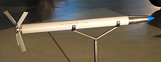
The Mighty Mouse unguided air-to-air missile was usually fired in salvoes from U. S. Navy and Air Force jet fighters. The fins unfolded When the rocket-left its firing tubeor pod. A single hit by one of these small missiles could destroy an enemy bomber.
The Navy Bureau of Ordnance began developing the missile in 1948. Used in the Korean and Vietnam wars, it became standard on many US. Navy and Air Force aircraft. Among the airplanes that carried them were the North American F 86D Sabre, Chance-Vought F 7U-3 Cutlass,Northrop F 89D Scorpion, and Lockheed F -104C Starfighter. Helicopters that carried them included the UH-l Iroquois, AH-1G HueyCobra Bell AH lJ SeaCobra, Lockheed AH-56A Cheyenne, and Sikorsky S-67 Blackhawk. Picture taken at the National Air and Space Museum's Steven F. Udvar-Hazy Center in Chantilly, Virginia, USA. - Transferred from the U. S. Navy, Naval Supply Depot, Mechanicsburg, Pa. Specifications: |
| Date | |
| Source | Own work |
| Author | Sanjay Acharya |
| Camera location | | View this and other nearby images on: OpenStreetMap |
|---|
Licensing
- You are free:
- to share – to copy, distribute and transmit the work
- to remix – to adapt the work
- Under the following conditions:
- attribution – You must give appropriate credit, provide a link to the license, and indicate if changes were made. You may do so in any reasonable manner, but not in any way that suggests the licensor endorses you or your use.
- share alike – If you remix, transform, or build upon the material, you must distribute your contributions under the same or compatible license as the original.
File history
Click on a date/time to view the file as it appeared at that time.
| Date/Time | Thumbnail | Dimensions | User | Comment | |
|---|---|---|---|---|---|
| current | 18:16, 2 February 2019 | 5,472 × 2,117 (9.43 MB) | Sanjay ach | User created page with UploadWizard |
File usage
Global file usage
The following other wikis use this file:
- Usage on fr.wikipedia.org
- Usage on ja.wikipedia.org
- Usage on sl.wikipedia.org