
Marker_at_Site_A.jpg (720 × 508 pixels, file size: 151 KB, MIME type: image/jpeg)
| This is a file from the Wikimedia Commons. Information from its description page there is shown below. Commons is a freely licensed media file repository. You can help. |
Summary
| Description |
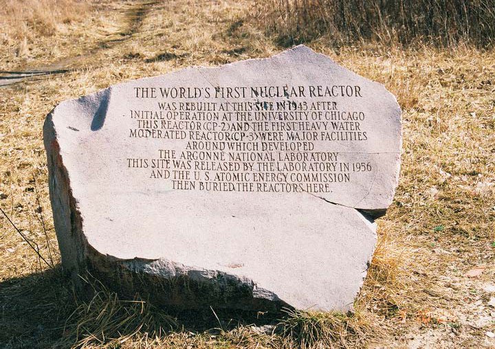
Site A/Plot M Disposal Site. Marker at Site A. Text of the inscription:
|
| Date | Unknown date |
| Source | Site A/Plot M Fact Sheet |
| Author | Federal Government of the United States |
| Camera location | | View this and other nearby images on: OpenStreetMap |
|---|
Licensing
| This image is a work of a United States Department of Energy (or predecessor organization) employee, taken or made as part of that person's official duties. As a work of the U.S. federal government, the image is in the public domain.
Please note that national laboratories operate under varying licences and some are not free. Check the site policies of any national lab before crediting it with this tag.
|

|
File history
Click on a date/time to view the file as it appeared at that time.
| Date/Time | Thumbnail | Dimensions | User | Comment | |
|---|---|---|---|---|---|
| current | 22:16, 20 September 2011 | | 720 × 508 (151 KB) | Bomazi | {{Information |Description ={{en|1={{w|Site A/Plot M Disposal Site}}. Marker at Site A,}} |Source =http://www.lm.doe.gov/sitea_plotm/Sites.aspx |Author =Federal Government of the United States |Date = |Permission ={{PD-USG |
File usage
Global file usage
The following other wikis use this file:
- Usage on de.wikipedia.org
- Usage on en.wikivoyage.org
- Usage on es.wikivoyage.org
- Usage on it.wikipedia.org
- Usage on ja.wikipedia.org