To install click the Add extension button. That's it.

The source code for the WIKI 2 extension is being checked by specialists of the Mozilla Foundation, Google, and Apple. You could also do it yourself at any point in time.

4,5
Kelly Slayton
Congratulations on this excellent venture… what a great idea!
Alexander Grigorievskiy
I use WIKI 2 every day and almost forgot how the original Wikipedia looks like.
Live Statistics
English Articles
Improved in 24 Hours
Added in 24 Hours
What we do. Every page goes through several hundred of perfecting techniques; in live mode. Quite the same Wikipedia. Just better.
.
Leo
Newton
Brights
Milds

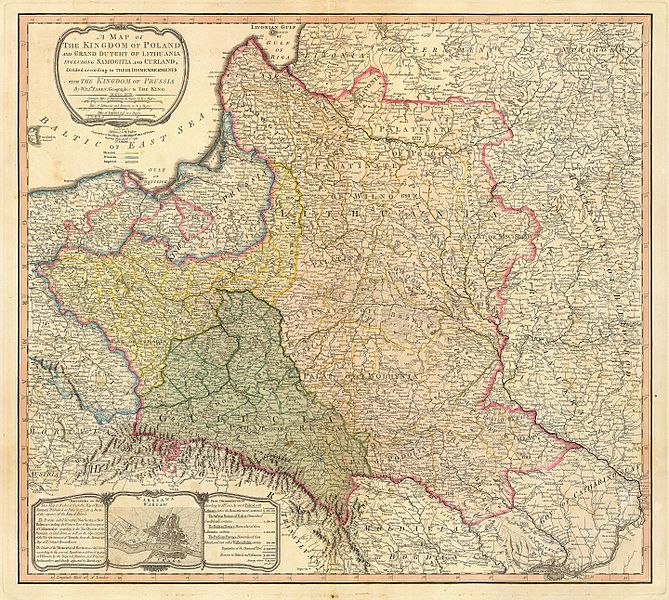
File:Map of the partition of the Kingdom of Poland and the Grand Duchy of Lithuania from 1799.jpg

From Wikipedia, the free encyclopedia

Original file(6,330 × 5,677 pixels, file size: 6.83 MB, MIME type: image/jpeg)

Summary

Description Title: "A map of the Kingdom of Poland and the Grand Duchy of Lithuania including Samogitia and Curland divided according to their dismemberments with the Kingdom of Prussia". A map from 1799 showing how the Polish-Lithuanian Commonwealth was partitioned in 1765-1795 between Prussia, Austria, and Russia. This is an extremely detailed map which lists all the cities and small towns and labels the regions according to their English names. The boundaries former Polish-Lithuanian Commonwealth colored light red. The areas taken by Prussia are colored yellow, those taken by Austria colored green, and those taken by Russia are colored beige. Prussia itself is bordered in blue. Eastern Pomerania and Warmia are shown as part of Prussia but bordered in red as well.
Date
Source http://www.belarusguide.com/images/maps/Kokosha/POlonia&Lituania-1799.jpg
Author
William Faden  (1749–1836)  wikidata:Q8008902
 
Alternative names
Faden & Jefferys
Description British cartographer and publisher
Date of birth/death circa 1750
date QS:P,+1750-00-00T00:00:00Z/9,P1480,Q5727902
21 March 1836 Edit this at Wikidata
Location of birth/death London Shepperton
Work location
From 1771: "Geographer to the King and to the Prince of Wales"
Authority file
creator QS:P170,Q8008902

Licensing

Public domain

This work is in the public domain in its country of origin and other countries and areas where the copyright term is the author's life plus 100 years or fewer.


You must also include a United States public domain tag to indicate why this work is in the public domain in the United States.

Captions

Add a one-line explanation of what this file represents

Items portrayed in this file

depicts

2 April 1799Gregorian

File history

Click on a date/time to view the file as it appeared at that time.

Date/TimeThumbnailDimensionsUserComment
current05:04, 23 September 2007Thumbnail for version as of 05:04, 23 September 20076,330 × 5,677 (6.83 MB)Archaeogenetics{{Information |Description=Title: "A map of the Kingdom of Poland and the Grand Duchy of Lithuania including Samogitia and Curland divided according to their dismemberments with the Kingdom of Prussia". A map from 1799 showing how the Polish-Lithuanian Co
The following pages on the English Wikipedia use this file (pages on other projects are not listed):

Global file usage

The following other wikis use this file:

Metadata

Basis of this page is in Wikipedia. Text is available under the CC BY-SA 3.0 Unported License. Non-text media are available under their specified licenses. Wikipedia® is a registered trademark of the Wikimedia Foundation, Inc. WIKI 2 is an independent company and has no affiliation with Wikimedia Foundation.