Size of this preview: 456 × 600 pixels. Other resolutions: 182 × 240 pixels | 570 × 750 pixels.
Original file (570 × 750 pixels, file size: 172 KB, MIME type: image/jpeg)
File history
Click on a date/time to view the file as it appeared at that time.
| Date/Time | Thumbnail | Dimensions | User | Comment | |
|---|---|---|---|---|---|
| current | 03:07, 30 March 2013 |  | 570 × 750 (172 KB) | Ras67 | cropped |
| 04:44, 3 December 2006 |  | 620 × 800 (122 KB) | Dedee73 | The first 13 american colonies | |
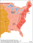
| 21:13, 6 June 2005 |  | 620 × 800 (122 KB) | Kooma | Map of territorial growth, 1775. From en.wiki. {{PD-USGov-Atlas}} Category:American Revolution |
File usage
The following pages on the English Wikipedia use this file (pages on other projects are not listed):
- Aboriginal title in the United States
- Aboriginal title statutes in the Thirteen Colonies
- American cuisine
- British North America
- Constitutional history of Canada
- Cultural assimilation of Native Americans
- Empire
- George Washington's political evolution
- History of Pennsylvania
- History of the United States (1776–1789)
- Public Land Survey System
- Timeline of the American Revolution
Global file usage
The following other wikis use this file:
- Usage on ar.wikipedia.org
- Usage on az.wikipedia.org
- Usage on bg.wikipedia.org
- Usage on bn.wikipedia.org
- Usage on ca.wikipedia.org
- Usage on da.wikipedia.org
- Usage on el.wikipedia.org
- Usage on en.wikibooks.org
- Usage on en.wikiversity.org
- Usage on fa.wikipedia.org
- Usage on fr.wikipedia.org
- Usage on fr.wikisource.org
- Usage on gl.wikipedia.org
- Usage on he.wikipedia.org
- Usage on hu.wikipedia.org
- Usage on hy.wikipedia.org
- Usage on it.wikipedia.org
- Usage on ja.wikipedia.org
- Usage on ka.wikipedia.org
- Usage on ko.wikipedia.org
- Usage on mwl.wikipedia.org
View more global usage of this file.


