

Size of this JPG preview of this PDF file: 450 × 600 pixels. Other resolutions: 180 × 240 pixels | 360 × 480 pixels | 576 × 768 pixels | 768 × 1,024 pixels | 1,536 × 2,048 pixels | 5,400 × 7,200 pixels.
Original file (5,400 × 7,200 pixels, file size: 4.05 MB, MIME type: application/pdf)
| This is a file from the Wikimedia Commons. Information from its description page there is shown below. Commons is a freely licensed media file repository. You can help. |
Summary
| Description |
Pickens County, Chickasaw Nation was one of four counties comprising the Chickasaw Nation in the Indian Territory. Its former territory now makes up all or parts of eight counties in Oklahoma. |
| Date | |
| Source | This file was created explicitly for this Wikipedia article by the Geographic Information Systems office of the Choctaw Nation of Oklahoma. For more information contact [email protected]. The map is one of several developed to illustrate articles regarding the Choctaw Nation's former districts and counties. |
| Author | Austin Joines, cartographer. |
| Permission (Reusing this file) |
This work was created by the Geographic Information Systems office of the Choctaw Nation of Oklahoma, as part of a series of maps designed to illustrate Wikipedia articles regarding the Nation's former districts and counties.
Licensing
This file is licensed under the Creative Commons Attribution-Share Alike 4.0 International license.
- You are free:
- to share – to copy, distribute and transmit the work
- to remix – to adapt the work
- Under the following conditions:
- attribution – You must give appropriate credit, provide a link to the license, and indicate if changes were made. You may do so in any reasonable manner, but not in any way that suggests the licensor endorses you or your use.
- share alike – If you remix, transform, or build upon the material, you must distribute your contributions under the same or compatible license as the original.
File history
Click on a date/time to view the file as it appeared at that time.
| Date/Time | Thumbnail | Dimensions | User | Comment | |
|---|---|---|---|---|---|
| current | 21:14, 2 June 2020 | 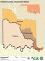 | 5,400 × 7,200 (4.05 MB) | Oklahombre | Reverted to version as of 20:57, 2 June 2020 (UTC) |
| 21:08, 2 June 2020 |  | 5,400 × 7,200 (4.34 MB) | Oklahombre | Reverted to version as of 17:53, 31 May 2020 (UTC) | |
| 20:57, 2 June 2020 |  | 5,400 × 7,200 (4.05 MB) | Oklahombre | Map was amended slightly to include an inset showing the location of the county within the present-day State of Oklahoma. | |
| 17:53, 31 May 2020 | 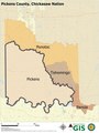 | 5,400 × 7,200 (4.34 MB) | Oklahombre | Uploaded a work by Austin Joines, cartographer. from This file was created explicitly for this Wikipedia article by the Geographic Information Systems office of the Choctaw Nation of Oklahoma. For more information contact [email protected]. The map is one of several developed to illustrate articles regarding the Choctaw Nation's former districts and counties. with UploadWizard |
File usage
The following pages on the English Wikipedia use this file (pages on other projects are not listed):