

Size of this preview: 800 × 480 pixels. Other resolutions: 320 × 192 pixels | 1,024 × 614 pixels | 1,280 × 767 pixels | 3,196 × 1,916 pixels.
Original file (3,196 × 1,916 pixels, file size: 6.09 MB, MIME type: image/jpeg)
| This is a file from the Wikimedia Commons. Information from its description page there is shown below. Commons is a freely licensed media file repository. You can help. |
Summary
| Description |
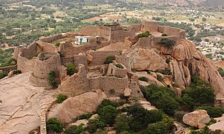
Madakasira Hill Fort is called as SIMHAGIRI Hill Fort because the hill from one side looks like a sleeping lion.The 2936 feet msl highly Fortified Hill is in Anantapur Dist of AndhraPradesh which was once, one of the stronghold of Vijayanagara Kingdom.Under Vijayanagara, the Madakasira was fortified strongly by the chiefs of Sira,especially under Hira Vdaiyar. But after the fall of Vijayanagara, it was taken by 'the Sultanate of Bijapur' but then left it back to him along with forts of Ratnagiri. In 1728 the Marathas captured Madakasira, and in 1741 the Ratnagiri Fort was taken by Morari Rao (Army General,Maratha) and imposed tribute of 8000/-. In 1762 Haidar Ali of Mysore took Madakasira, but his troops were ejected two years later by Morari Rao. Haidar seized it again in 1776 and demanded a tribute of 15000/-. On failing upon this, he send the chief and his five sons as prisoners to Seringapatam. In 1799 the country fell under British rule.
The town is now a fairly important market center. The Fort entrance, two main large bastions, and parts of the forts still remains in the city apart from the Fortification in the Hill.They are under ASI. Parts of the film 'Krishna Gaadi Veera Prema Gaadha' was shot in this fort.
|
||
| Date | |||
| Source | Own work | ||
| Author | Gopakumar V R |
| Camera location | | View this and other nearby images on: OpenStreetMap |
|---|
Licensing
I, the copyright holder of this work, hereby publish it under the following license:
This file is licensed under the Creative Commons Attribution-Share Alike 4.0 International license.
- You are free:
- to share – to copy, distribute and transmit the work
- to remix – to adapt the work
- Under the following conditions:
- attribution – You must give appropriate credit, provide a link to the license, and indicate if changes were made. You may do so in any reasonable manner, but not in any way that suggests the licensor endorses you or your use.
- share alike – If you remix, transform, or build upon the material, you must distribute your contributions under the same or compatible license as the original.

|
This image was uploaded as part of Wiki Loves Monuments 2018.
|
 |
File history
Click on a date/time to view the file as it appeared at that time.
| Date/Time | Thumbnail | Dimensions | User | Comment | |
|---|---|---|---|---|---|
| current | 17:34, 3 September 2018 | | 3,196 × 1,916 (6.09 MB) | Gopakumar V R | User created page with UploadWizard |
File usage
The following pages on the English Wikipedia use this file (pages on other projects are not listed):
Global file usage
The following other wikis use this file:
- Usage on azb.wikipedia.org
- Usage on hi.wikipedia.org
- Usage on pa.wikipedia.org
- Usage on ta.wikipedia.org
- Usage on te.wikipedia.org
- Usage on www.wikidata.org