To install click the Add extension button. That's it.

The source code for the WIKI 2 extension is being checked by specialists of the Mozilla Foundation, Google, and Apple. You could also do it yourself at any point in time.

4,5
Kelly Slayton
Congratulations on this excellent venture… what a great idea!
Alexander Grigorievskiy
I use WIKI 2 every day and almost forgot how the original Wikipedia looks like.
Live Statistics
English Articles
Improved in 24 Hours
Added in 24 Hours
What we do. Every page goes through several hundred of perfecting techniques; in live mode. Quite the same Wikipedia. Just better.
.
Leo
Newton
Brights
Milds

File:Luton Ward Map.png

From Wikipedia, the free encyclopedia

Original file(1,599 × 1,200 pixels, file size: 1.41 MB, MIME type: image/png)

Summary

Description
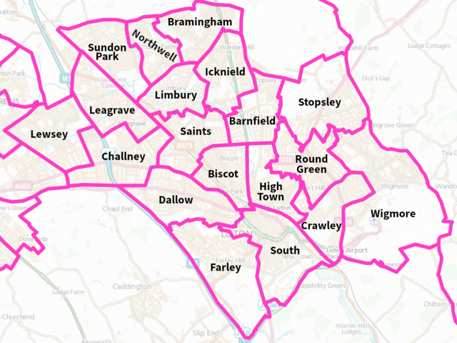
Map of Luton, Bedfordshire, England. Divided into its 19 wards, with their names labelled. Based on Ordnance Survey election data.
Date
Source Own work
Author Oliver Galvin
Camera location51° 53′ 00″ N, 0° 25′ 00″ W Kartographer map based on OpenStreetMap.View this and other nearby images on: OpenStreetMapinfo

Based on Ordnance Survey election map data, Copyright Ordnance Survey Limited and Crown Copyright, which is released under the Open Government License (OGL) version 3, compatible with CC-BY version 4. The font for the labels is Adobe Source Sans Pro, an open source font.

 
This PNG graphic was created with GIMP.

Links

Licensing

I, the copyright holder of this work, hereby publish it under the following license:
w:en:Creative Commons
attribution
This file is licensed under the Creative Commons Attribution 4.0 International license.
You are free:
  • to share – to copy, distribute and transmit the work
  • to remix – to adapt the work
Under the following conditions:
  • attribution – You must give appropriate credit, provide a link to the license, and indicate if changes were made. You may do so in any reasonable manner, but not in any way that suggests the licensor endorses you or your use.
This file is licensed under the United Kingdom Open Government Licence v3.0.
You are free to:
  • copy, publish, distribute and transmit the Information;
  • adapt the Information;
  • exploit the Information commercially and non-commercially for example, by combining it with other Information, or by including it in your own product or application.
You must, where you do any of the above:
  • acknowledge the source of the Information in your product or application by including or linking to any attribution statement specified by the Information Provider(s) and, where possible, provide a link to this licence;
  • If the Information Provider does not provide a specific attribution statement, you must use the following:
Contains public sector information licensed under the Open Government Licence v3.0.
This licence does NOT cover:
  • personal data in the Information;
  • Information that has not been accessed by way of publication or disclosure under information access legislation (including the Freedom of Information Acts for the UK and Scotland) by or with the consent of the Information Provider;
  • departmental or public sector organisation logos, crests and the Royal Arms except where they form an integral part of a document or dataset;
  • military insignia;
  • third party rights the Information Provider is not authorised to license;
  • other intellectual property rights, including patents, trade marks, and design rights; and
  • identity documents such as the British Passport.
Consult this guide for full details.
Note: Since 2010, almost all information owned by the UK Crown is offered for use and re-use under the Open Government Licence by authority of The Controller of His Majesty's Stationery Office.info
See also: Meta for information on usage on Wikimedia wikis.

Captions

Map of Luton divided into its 19 wards

Items portrayed in this file

depicts

21 March 2019

51°52'59.999"N, 0°25'0.001"W

File history

Click on a date/time to view the file as it appeared at that time.

Date/TimeThumbnailDimensionsUserComment
current14:49, 25 March 2019Thumbnail for version as of 14:49, 25 March 20191,599 × 1,200 (1.41 MB)OliverGalvinAdjust position and spacing of labels slightly to improve readability
19:59, 21 March 2019Thumbnail for version as of 19:59, 21 March 20191,599 × 1,200 (1.41 MB)OliverGalvinUser created page with UploadWizard
The following pages on the English Wikipedia use this file (pages on other projects are not listed):

Metadata

Basis of this page is in Wikipedia. Text is available under the CC BY-SA 3.0 Unported License. Non-text media are available under their specified licenses. Wikipedia® is a registered trademark of the Wikimedia Foundation, Inc. WIKI 2 is an independent company and has no affiliation with Wikimedia Foundation.