

Size of this JPG preview of this TIF file: 800 × 271 pixels. Other resolutions: 320 × 108 pixels | 640 × 217 pixels | 1,024 × 347 pixels | 1,280 × 433 pixels | 2,560 × 867 pixels | 7,127 × 2,413 pixels.
Original file (7,127 × 2,413 pixels, file size: 49.2 MB, MIME type: image/tiff)
| This is a file from the Wikimedia Commons. Information from its description page there is shown below. Commons is a freely licensed media file repository. You can help. |
Summary
| Description |
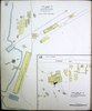
1919. 38 Sheet(s). Includes Map of the Territory of Hawaii. Bound. |
||
| Title | Sanborn Fire Insurance Map from Sugar Mill and Cannery, Hawaii County, Hawaii. | ||
| Shelf ID | https://www.loc.gov/item/sanborn01553_001/ | ||
| Parent | https://www.loc.gov/resource/g4380m.g015531919/ | ||
| Sheet title | Image 11 of Sanborn Fire Insurance Map from Sugar Mill and Cannery, Hawaii County, Hawaii. | ||
| Date | |||
| Source | https://www.loc.gov/item/sanborn01553_001/ | ||
| Author | Unknown author | ||
| Permission (Reusing this file) |
|
||
| Other versions |
|
||
| Location | Hawaii County · Map Of The Territory Of Hawaii · Hawaii · Sugar Mill · Cannery | ||
| Part of | American Memory · Sanborn Maps · Geography And Maps Division · Sanborn Fire Insurance Maps |


Licensing
|
This is a faithful photographic reproduction of a two-dimensional, public domain work of art. The work of art itself is in the public domain for the following reason:
The official position taken by the Wikimedia Foundation is that "faithful reproductions of two-dimensional public domain works of art are public domain".
This photographic reproduction is therefore also considered to be in the public domain in the United States. In other jurisdictions, re-use of this content may be restricted; see Reuse of PD-Art photographs for details. | ||||
File history
Click on a date/time to view the file as it appeared at that time.
| Date/Time | Thumbnail | Dimensions | User | Comment | |
|---|---|---|---|---|---|
| current | 03:11, 13 July 2020 | 7,127 × 2,413 (49.2 MB) | <bdi>Tibet Nation</bdi> | File:Sanborn Fire Insurance Map from Sugar Mill and Cannery, Hawaii County, Hawaii. LOC sanborn01553 001-11.tif cropped -11 % horizontally, 69 % vertically, rotated 90° using CropTool with precise mode. |
File usage
The following pages on the English Wikipedia use this file (pages on other projects are not listed):