

Size of this preview: 800 × 532 pixels. Other resolutions: 320 × 213 pixels | 640 × 426 pixels | 1,024 × 681 pixels | 1,280 × 851 pixels | 2,560 × 1,702 pixels | 6,016 × 4,000 pixels.
Original file (6,016 × 4,000 pixels, file size: 6.78 MB, MIME type: image/jpeg)
| This is a file from the Wikimedia Commons. Information from its description page there is shown below. Commons is a freely licensed media file repository. You can help. |
|
This is an image of a place or building that is listed on the National Register of Historic Places in the United States of America. Its reference number is 78001114. |
| Camera location | | View this and other nearby images on: OpenStreetMap |
|---|
| Description |
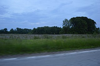
Fields on the western side of Illinois Route 100 north of Kampsville in Carlin Precinct, Calhoun County, Illinois, United States. These fields are part of the village associated with the Kamp Mound Site; as an important archaeological site, it is listed on the National Register of Historic Places. |
||
| Date | Taken on 26 May 2014 | ||
| Source | Own work | ||
| Author | Nyttend | ||
| Permission (Reusing this file) |
|
File history
Click on a date/time to view the file as it appeared at that time.
| Date/Time | Thumbnail | Dimensions | User | Comment | |
|---|---|---|---|---|---|
| current | 16:25, 4 June 2014 | | 6,016 × 4,000 (6.78 MB) | Nyttend | {{NRHP|78001114}} {{Location|39|19|54|N|90|37|16|W}} {{Information |Description={{en|Fields on the western side of {{w|Illinois Route 100}} north of {{w|Kampsville, Illinois|Kampsville}} in {{w|Carlin Precinct, Calhoun County, Illinois|Carlin Precinct}... |
File usage
The following pages on the English Wikipedia use this file (pages on other projects are not listed):
Global file usage
The following other wikis use this file:
- Usage on de.wikipedia.org
- Usage on www.wikidata.org