
Size of this preview: 408 × 600 pixels. Other resolutions: 163 × 240 pixels | 326 × 480 pixels | 522 × 768 pixels | 696 × 1,024 pixels | 1,893 × 2,783 pixels.
Original file (1,893 × 2,783 pixels, file size: 1.57 MB, MIME type: image/jpeg)
| This is a file from the Wikimedia Commons. Information from its description page there is shown below. Commons is a freely licensed media file repository. You can help. |
Summary
| Description |
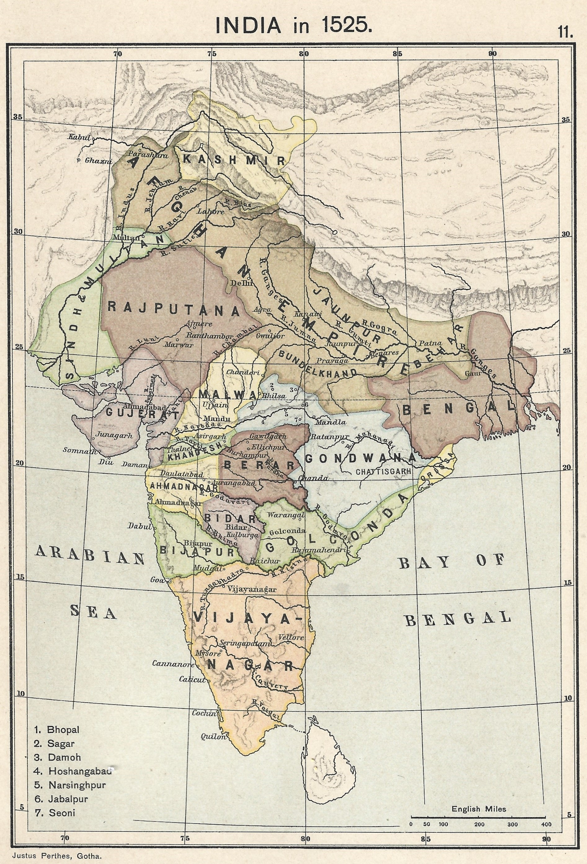
A map of India in 1525 on the eve of the Mughal conquest of Upper India, scanned from the personal copy of Historical Atlas of India by Charles Joppen SJ, Longmans, Green and Co, 1907 by Fowler&fowler (talk) 13:52, 10 July 2023 (UTC) |
| Date | |
| Source | Map of India 1525 showing India just before the Mughal conquest of Upper India from: Joppen, Charles [SJ.] (1907) A Historical Atlas of India for the use of High-Schools, Colleges, and Private Students, London, New York, Bombay, and Calcutta: Longman Green and Co. Pp. 16, 26 maps. |
| Author | Justus Perthes, Gotha./Charles Joppen Joppen, Charles [SJ.] (1907) A Historical Atlas of India for the use of High-Schools, Colleges, and Private Students, London, New York, Bombay, and Calcutta: Longman Green and Co. Pp. 16, 26 maps |
Licensing
This work is in the public domain in the United States because it was published (or registered with the U.S. Copyright Office) before January 1, 1929.
Public domain works must be out of copyright in both the United States and in the source country of the work in order to be hosted on the Commons. If the work is not a U.S. work, the file must have an additional copyright tag indicating the copyright status in the source country.
Note: This tag should not be used for sound recordings. |
File history
Click on a date/time to view the file as it appeared at that time.
| Date/Time | Thumbnail | Dimensions | User | Comment | |
|---|---|---|---|---|---|
| current | 13:52, 10 July 2023 | | 1,893 × 2,783 (1.57 MB) | Fowler&fowler | Uploaded a work by Justus Perthes, Gotha./Charles Joppen {{Citation|last=Joppen|first=Charles [SJ.]|year=1907|title=A Historical Atlas of India for the use of High-Schools, Colleges, and Private Students|publisher=London, New York, Bombay, and Calcutta: Longman Green and Co. Pp. 16, 26 maps}} from Map of India 1700 showing the Mughal Empire and European trading posts/factory towns from: {{Citation|last=Joppen|first=Charles [SJ.]|year=1907|title=A Historical Atlas of India for the use of High-... |
File usage
The following pages on the English Wikipedia use this file (pages on other projects are not listed):
Global file usage
The following other wikis use this file:
- Usage on ko.wikipedia.org