To install click the Add extension button. That's it.

The source code for the WIKI 2 extension is being checked by specialists of the Mozilla Foundation, Google, and Apple. You could also do it yourself at any point in time.

4,5
Kelly Slayton
Congratulations on this excellent venture… what a great idea!
Alexander Grigorievskiy
I use WIKI 2 every day and almost forgot how the original Wikipedia looks like.
Live Statistics
English Articles
Improved in 24 Hours
Added in 24 Hours
What we do. Every page goes through several hundred of perfecting techniques; in live mode. Quite the same Wikipedia. Just better.
.
Leo
Newton
Brights
Milds

File:ISS029-E-008032 Fires along the Rio Xingu - Brazil.jpg

From Wikipedia, the free encyclopedia

Original file(4,288 × 2,848 pixels, file size: 8.76 MB, MIME type: image/jpeg)

Summary

Description
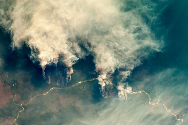
Slash-and-burn forest clearing along the Rio Xingu (Xingu River) in the state of Mato Grosso, Brazil.


International Space Station InsigniaISS Crew Earth Observations: ISS029-E-8032International Space Station Insignia
Identification
Mission ISS029 (Expedition 29)
Roll E
Frame 8032
Country or Geographic Name BRAZIL
Features RIO XINGU, FOREST, AMAZONIA, SMOKE PLUMES
Center Point Latitude -11.8° N
Center Point Longitude -53.6° E
Camera
Camera Tilt 28°
Camera Focal Length 200 mm
Camera Nikon D2Xs
Film 4288 x 2848 pixel CMOS sensor, RGBG imager color filter.
Quality
Percentage of Cloud Cover 0-10%
Nadir What is Nadir?
Date 2011-09-17
Time 20:13:03
Nadir Point Latitude -12.8° N
Nadir Point Longitude -55.1° E
Nadir to Photo Center Direction Northeast
Sun Azimuth 277°
Spacecraft Altitude 205 nautical miles (380 km)
Sun Elevation Angle 19°
Orbit Number 1537
Original image caption
The rain forest of South America, also known as “Amazonia”—the largest such forest on Earth—has been undergoing a continual and accelerated land use conversion process into farmlands (including pasture for livestock) since the early 1960s. This process has typically been achieved by clearing of the forest using fire – “slash and burn” – followed by planting of crops. The generally infertile soils of the region make sustainable farming difficult; this drives more forest conversion into new farmland. The area of clearing can be considerable, and as the deforested regions are easily identifiable and measurable from space the rate of deforestation is likewise easy to track.

This detailed astronaut photograph illustrates slash-and-burn forest clearing along the Xingu River (Rio) in the northeast of the state of Matto Grasso, Brazil. The image was taken from the International Space Station, a platform from which astronauts can take imagery of the Earth from a variety of viewing angles. The perspective of this image allows for a striking visualization of both the horizontal position and extent of the fire lines next to the river, as well as providing a sense of the vertical structure of the smoke plumes due to the viewing angle and shadowing.

Light colored areas within the river channel are sand bars, which show that the river is in its annual low-flow/ low water stage. For a sense of scale, the Xingu River channel within the view is approximately 63 kilometers long. Rivers in Amazonia are its natural highways, which may explain why the burning is occurring right next to the Xingu River, one of Amazonia’s largest. In recent years, preservation has gained traction in the region as a result of such considerations as new valuation of the ecosystem services provided by the forest, concerns about the impact of widespread burning on global climate change, and greater sensitivity to the ethnic and biological heritage of Amazonia.

Date
Source ISS029-E-8032
Author
  • Expedition 29 Crew
  • Image courtesy of the Image Science & Analysis Laboratory, NASA Johnson Space Center
  • Derivative work including grading, noise removal and hotpixel corrections.: Julian Herzog
Other versions
Public domain
This file is in the public domain in the United States because it was created by the Image Science & Analysis Laboratory, of the NASA Johnson Space Center. NASA copyright policy states that "NASA material is not protected by copyright unless noted". (NASA media use guidelines or Conditions of Use of Astronaut Photographs). Photo source: ISS029-E-008032.

العربيَّة | Deutsch | English | español | français | italiano | kurdî | македонски | മലയാളം | português | sicilianu | +/−

Licensing

Public domain This file is in the public domain in the United States because it was solely created by NASA. NASA copyright policy states that "NASA material is not protected by copyright unless noted". (See Template:PD-USGov, NASA copyright policy page or JPL Image Use Policy.)
Warnings:

Captions

Satellite photograph illustrating slash-and-burn forest clearing along the Xingu River in the state of Mato Grosso, Brazil

Items portrayed in this file

depicts

17 September 2011

File history

Click on a date/time to view the file as it appeared at that time.

Date/TimeThumbnailDimensionsUserComment
current09:55, 27 April 2013Thumbnail for version as of 09:55, 27 April 20134,288 × 2,848 (8.76 MB)Julian HerzogUser created page with UploadWizard
The following pages on the English Wikipedia use this file (pages on other projects are not listed):

Global file usage

Metadata

Basis of this page is in Wikipedia. Text is available under the CC BY-SA 3.0 Unported License. Non-text media are available under their specified licenses. Wikipedia® is a registered trademark of the Wikimedia Foundation, Inc. WIKI 2 is an independent company and has no affiliation with Wikimedia Foundation.