

Size of this preview: 800 × 399 pixels. Other resolutions: 320 × 160 pixels | 640 × 319 pixels | 1,024 × 511 pixels | 1,280 × 639 pixels | 3,033 × 1,514 pixels.
Original file (3,033 × 1,514 pixels, file size: 1.56 MB, MIME type: image/png)
| This is a file from the Wikimedia Commons. Information from its description page there is shown below. Commons is a freely licensed media file repository. You can help. |
Summary
| Description |
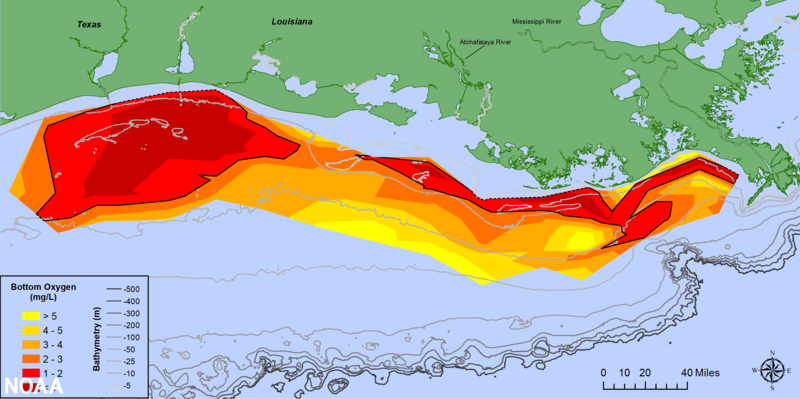
The 2021 Gulf of Mexico Hypoxic Zone, or Dead Zone, an area of low oxygen that can kill fish and marine life near the bottom of the sea, measures 2,116 square miles. This is the 3rd smallest dead zone in the Gulf since mapping of the zone began in 1985. |
| Date | |
| Source | https://oceantoday.noaa.gov/happenowdeadzone/ |
| Author |
NOAA. https://oceantoday.noaa.gov/about.html#one |
Licensing
This image is in the public domain because it contains materials that originally came from the U.S. National Oceanic and Atmospheric Administration, taken or made as part of an employee's official duties.
|
File history
Click on a date/time to view the file as it appeared at that time.
| Date/Time | Thumbnail | Dimensions | User | Comment | |
|---|---|---|---|---|---|
| current | 11:29, 16 February 2022 | | 3,033 × 1,514 (1.56 MB) | ASRASR | Uploaded a work by NOAA. https://oceantoday.noaa.gov/about.html#one from https://oceantoday.noaa.gov/happenowdeadzone/ with UploadWizard |
File usage
The following pages on the English Wikipedia use this file (pages on other projects are not listed):