

Size of this JPG preview of this PDF file: 800 × 518 pixels. Other resolutions: 320 × 207 pixels | 640 × 414 pixels | 1,024 × 663 pixels | 1,280 × 828 pixels | 2,550 × 1,650 pixels.
Original file (2,550 × 1,650 pixels, file size: 674 KB, MIME type: application/pdf)
| This is a file from the Wikimedia Commons. Information from its description page there is shown below. Commons is a freely licensed media file repository. You can help. |
Summary
| Description |
Topographic map of the Ponkapoag Pond area of the Blue Hills Reservation in Massachusetts, with hypsometric tinted contour lines.
Source data provided by the Office of Geographic Information (MassGIS), Commonwealth of Massachusetts Information Technology Division. |
| Date | |
| Source | Own work |
| Author | Belg4mit |
Licensing
I, the copyright holder of this work, hereby publish it under the following license:
| This file is made available under the Creative Commons CC0 1.0 Universal Public Domain Dedication. | |
| The person who associated a work with this deed has dedicated the work to the public domain by waiving all of their rights to the work worldwide under copyright law, including all related and neighboring rights, to the extent allowed by law. You can copy, modify, distribute and perform the work, even for commercial purposes, all without asking permission.
|
File history
Click on a date/time to view the file as it appeared at that time.
| Date/Time | Thumbnail | Dimensions | User | Comment | |
|---|---|---|---|---|---|
| current | 20:33, 6 August 2011 | 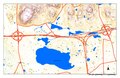 | 2,550 × 1,650 (674 KB) | Belg4mit | {{Information |Description ={{en|1=Topographic map of the Ponkapoag Pond area of the Wikipedia:Blue Hills Reservation in Massachusetts, with Wikipedia:hypsometric tint colored Wikipedia:contour lines.}} |Source ={{own}} |Author |
File usage
The following pages on the English Wikipedia use this file (pages on other projects are not listed):
Global file usage
The following other wikis use this file:
- Usage on es.wikipedia.org