

Original file (1,120 × 790 pixels, file size: 473 KB, MIME type: image/png)
| This is a file from the Wikimedia Commons. Information from its description page there is shown below. Commons is a freely licensed media file repository. You can help. |
Summary
| Description |
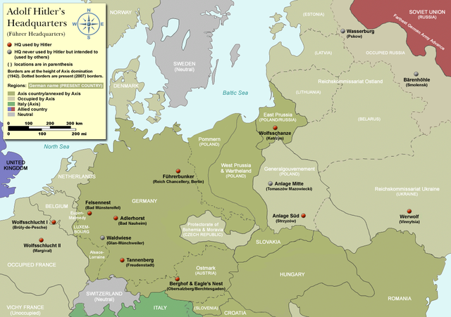
Map of Adolf Hitler's Headquarters (Führer Headquarters) in Europe 1933-1945. Countries that were part of the Axis/annexed by Axis are colored dark green (Germany, Austria, Hungary, Romania & Italy etc). |
| Date | |
| Source | Self-made, based on information from references below |
| Author | User:Dna-Dennis |
| Permission (Reusing this file) |
CC, see below. The map is completely unrestricted for any Wikipedia/Wikimedia project. If you have any opinions/suggestions, please contact me here on my talk page. |
| Other versions |
|


.png)

|
This historical map image could be re-created using vector graphics as an SVG file. This has several advantages; see Commons:Media for cleanup for more information. If an SVG form of this image is available, please upload it and afterwards replace this template with
{{vector version available|new image name}}.
It is recommended to name the SVG file “Hitler-Headquarters-Europe.svg”—then the template Vector version available (or Vva) does not need the new image name parameter. |
Licensing
- You are free:
- to share – to copy, distribute and transmit the work
- to remix – to adapt the work
- Under the following conditions:
- attribution – You must give appropriate credit, provide a link to the license, and indicate if changes were made. You may do so in any reasonable manner, but not in any way that suggests the licensor endorses you or your use.
References
- Beevor, Antony, Berlin - The Downfall 1945
- Eberle, Henrik and Uhl, Matthias, The Unknown Hitler
- Hansen, Hans-Josef: Felsennest - Das vergessene Führerhauptquartier in der Eifel. Bau, Nutzung, Zerstörung. Aachen 2006, Helios-Verlag, ISBN 3-938208-21-X.
- Kuffner, Alexander: Zeitreiseführer Eifel 1933-45. Helios, Aachen 2007, ISBN 978-3-938208-42-7.
- Raiber, Richard, Guide to Hitler's Headquarters, After the Battle archive copy at the Wayback Machine, No.19, Special Edition, Battle of Britain International Ltd, 1977, London
- Ramsey, Winston G. (editor) & Posch, Tom (researcher), The Berlin Führerbunker: The Thirteenth Hole, After the Battle archive copy at the Wayback Machine, No.61, Special Edition, Battle of Britain International Ltd, 1988, London
- von Loringhoven, Bernd Freytag/d’Alançon, François: Mit Hitler im Bunker. Aufzeichnungen aus dem Führerhauptquartier Juli 1944 – April 1945. Berlin 2005, wjs-Verlag, ISBN 3-937989-14-5.
- Schulz, Alfons: Drei Jahre in der Nachrichtenzentrale des Führerhauptquartiers. Christiana-Verlag, Stein am Rhein. 2. Aufl. 1997. ISBN 3-7171-1028-4.
- Seidler, Franz W./Zeigert, Dieter : Die Führerhauptquartiere. Anlagen und Planungen im Zweiten Weltkrieg. München: Herbig 2000. ISBN 3-7766-2154-0.
Notes on the individual headquarters
- Adlerhorst (Guide to Hitler's Headquarters, p.51)
- Anlage Mitte (Guide to Hitler's Headquarters, p.48)
- Anlage Süd (Guide to Hitler's Headquarters, p.48)
- Berghof/Eagle's nest (Guide to Hitler's Headquarters, p.2) - please note that the "Eagle's nest" was rarely used
- Bärenhöhle (www.bundesarchiv.de)
- Felsennest (Guide to Hitler's Headquarters, p.4)
- Führerbunker (After The Battle, No.61 (entire))
- Tannenberg (Guide to Hitler's Headquarters, p.18)
- Waldwiese (www.bundesarchiv.de)
- Wasserburg (www.bundesarchiv.de)
- Werwolf (Guide to Hitler's Headquarters, p.48)
- Wolfsschanze (Guide to Hitler's Headquarters, p.28)
- Wolfsschlucht I (Guide to Hitler's Headquarters, p.10)
- Wolfsschlucht II (Guide to Hitler's Headquarters, p.49)
File history
Click on a date/time to view the file as it appeared at that time.
| Date/Time | Thumbnail | Dimensions | User | Comment | |
|---|---|---|---|---|---|
| current | 08:19, 3 April 2012 | | 1,120 × 790 (473 KB) | Asav | Wehrwolf -> Werwolf (Correct name, see "Naming" section on en.wp) |
| 03:54, 20 December 2007 |  | 1,120 × 790 (537 KB) | Dna-webmaster~commonswiki | completely new version with 1942 borders | |
| 23:32, 16 December 2007 |  | 1,120 × 790 (408 KB) | Dna-webmaster~commonswiki | updated map - please suggest changes before making any bold moves, please | |
| 17:25, 10 December 2007 |  | 1,096 × 704 (37 KB) | Matthead | Modified version, file size reduced, country coloring removed (countries as of 2007 were not involved in WW2) | |
| 04:27, 21 October 2007 |  | 1,120 × 790 (407 KB) | Dna-webmaster~commonswiki | new version with new colors | |
| 14:11, 16 October 2007 |  | 1,120 × 790 (447 KB) | Dna-webmaster~commonswiki | new version | |
| 20:46, 14 October 2007 |  | 1,120 × 790 (423 KB) | Dna-webmaster~commonswiki | quick update | |
| 20:38, 14 October 2007 |  | 1,120 × 790 (425 KB) | Dna-webmaster~commonswiki | {{Information |Description=Map of Adolf Hitler's Headquarters (Führer Headquarters) in Europe 1933-1945.<br><br> For more detailed information, please see below. |Source=Self-made |Date=October 14, 2007 |Author=[http://en.wikipedia.org/wiki/User:Dna-webm |
File usage
Global file usage
The following other wikis use this file:
- Usage on ar.wikipedia.org
- Usage on ast.wikipedia.org
- Usage on ba.wikipedia.org
- Usage on bg.wikipedia.org
- Usage on ca.wikipedia.org
- Usage on cs.wikipedia.org
- Usage on da.wikipedia.org
- Usage on el.wikipedia.org
- Usage on es.wikipedia.org
- Usage on et.wikipedia.org
- Usage on fi.wikipedia.org
- Usage on fr.wikipedia.org
- Usage on he.wikipedia.org
- Usage on id.wikipedia.org
- Usage on it.wikipedia.org
- Usage on ja.wikipedia.org
- Usage on ko.wikipedia.org
- Usage on ms.wikipedia.org
- Usage on nl.wikipedia.org
- Usage on no.wikipedia.org
- Usage on pl.wikipedia.org
- Usage on pt.wikipedia.org
- Usage on ru.wikipedia.org
- Usage on sv.wikipedia.org
View more global usage of this file.