
_-_Haubois,_1652_jpg)
Original file (3,000 × 2,493 pixels, file size: 2.11 MB, MIME type: image/jpeg)
| This is a file from the Wikimedia Commons. Information from its description page there is shown below. Commons is a freely licensed media file repository. You can help. |
_-_Haubois,_1652.jpg)
Summary
| Description |
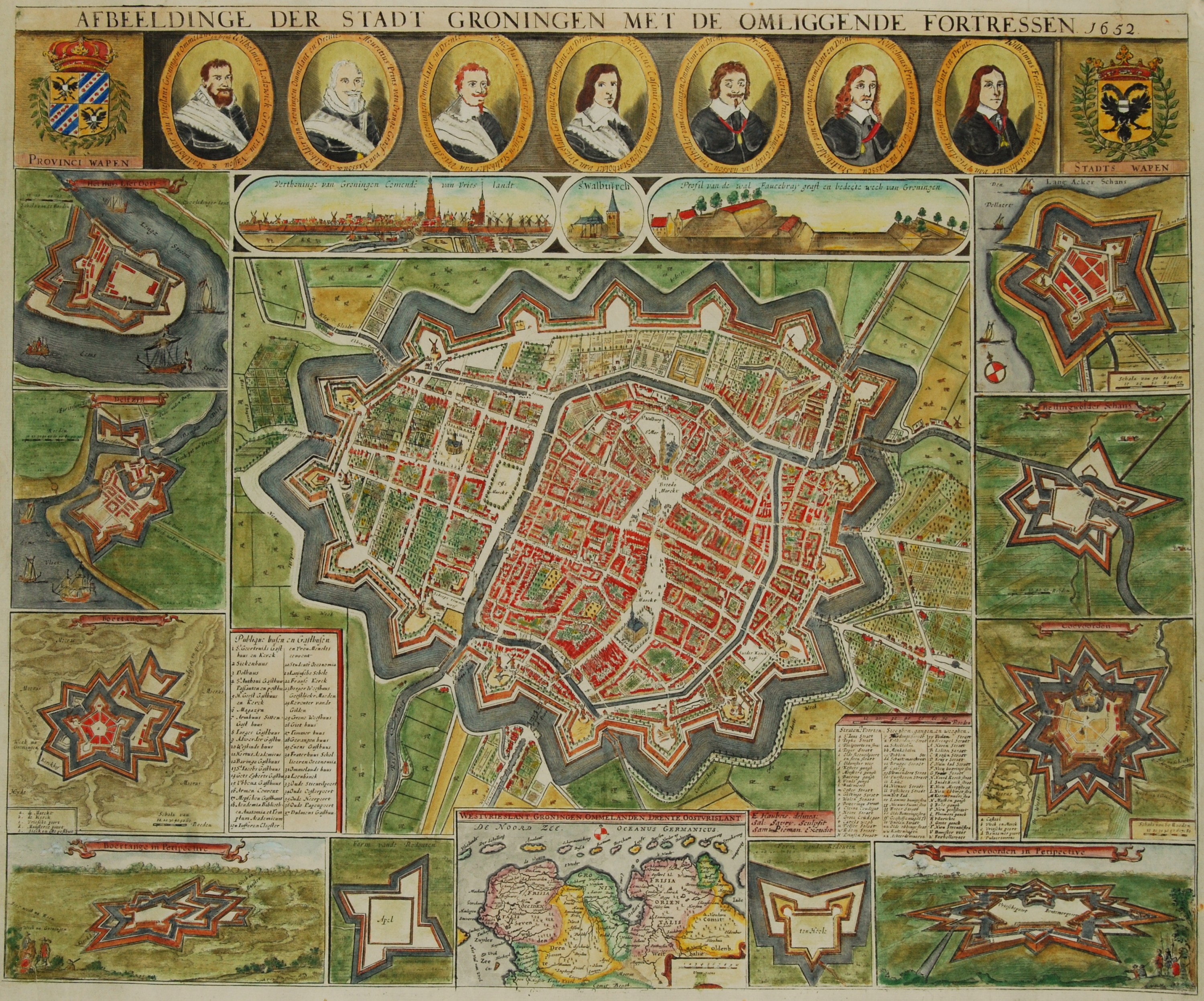
Nederlands: “AFBEELDINGE DER STADT GRONINGEN MET DE OMLIGGENDE FORTRESSEN 1652”, de zogeheten ‘Kleine Haubois’
Kopergravure vervaardigd door Salomon Savery naar het ontwerp van Egbert Haubois, uitgegeven door Samuel Pieman. 5e uitgave (van V), waarbij midden onderaan een adres heeft gestaan, dat uit de koperplaat is weggewist. Egbert Haubois (ca. 1602/1610 – 1653) kreeg in 1631 toestemming van het stadsbestuur om deze “stadt in een coperen plaet uijt te snijden”. Wat hij vastlegde was de sterkste vestingstad in het noorden van de Republiek. Het stadsbestuur zocht na een uitbreiding van de vestingwerken in het begin van de 17e eeuw, naar mogelijkheden Groningen ook op economisch gebied een bloeiende metropool te maken. Maar de kaart toont dat aan het begin van de dertiger jaren de droom van voorspoed niet was uitgekomen, ambitieuze economische plannen waren niet verwezenlijkt en grote terreinen binnen de vestingwerken zijn onbebouwd gebleven. Haubois’ grote plattegrond werd uitgegeven in 1645. Dit ontwerp voor de plattegrond werd een aantal jaren later gebruikt als basis voor een verkleinde versie van de kaart (de zogeheten ‘Kleine Haubois’): de stad met omliggende vestingen. Met in de bovenrand de wapens van de provincie en de stad, en daartussen 7 portretten van stadhouders sinds 1594. Daaronder een stadsprofiel, een afbeelding van de St. Walburgkerk, en een profiel van een wal. In de linker rand plattegronden van vestingen: Lieroort, Delfzijl, en Bourtange. In de rechter rand plattegronden van de Langakkerschans, Bellingwolderschans en Coevorden. Ook in de benedenrand enkele vestingen. Midden onder een kaartje van de provincie Groningen, gebaseerd op de kaart van Barthold Wicheringe. |
| Date | |
| Source | Inter-Antiquariaat Mefferdt & De Jonge |
| Author |
Inter-Antiquariaat Mefferdt & De Jonge Samuel Pieman Salomon Savery Egbert Haubois |
Licensing
- You are free:
- to share – to copy, distribute and transmit the work
- to remix – to adapt the work
- Under the following conditions:
- attribution – You must give appropriate credit, provide a link to the license, and indicate if changes were made. You may do so in any reasonable manner, but not in any way that suggests the licensor endorses you or your use.
- share alike – If you remix, transform, or build upon the material, you must distribute your contributions under the same or compatible license as the original.
File history
Click on a date/time to view the file as it appeared at that time.
| Date/Time | Thumbnail | Dimensions | User | Comment | |
|---|---|---|---|---|---|
| current | 09:57, 13 November 2012 | | 3,000 × 2,493 (2.11 MB) | Zinnia~commonswiki | User created page with UploadWizard |
File usage
Global file usage
The following other wikis use this file:
- Usage on es.wikipedia.org
- Usage on nl.wikipedia.org
- Usage on nl.wiktionary.org
- Usage on sl.wikipedia.org
- Usage on zh.wikipedia.org
_-_Haubois,_1652.jpg)