

Size of this JPG preview of this TIF file: 800 × 574 pixels. Other resolutions: 320 × 230 pixels | 640 × 459 pixels | 1,024 × 735 pixels | 1,280 × 918 pixels | 2,560 × 1,837 pixels | 5,000 × 3,587 pixels.
Original file (5,000 × 3,587 pixels, file size: 17.11 MB, MIME type: image/tiff)
| This is a file from the Wikimedia Commons. Information from its description page there is shown below. Commons is a freely licensed media file repository. You can help. |
Summary
| General view looking south - Cartersville Bridge, Route 25, spanning James River, Cartersville, Cumberland County, VA | ||||
|---|---|---|---|---|
| Title |
General view looking south - Cartersville Bridge, Route 25, spanning James River, Cartersville, Cumberland County, VA |
|||
| Description |
Morris, Scott, transmitter; DeBoer, Ruth, transmitter |
|||
| Depicted place | Virginia; Cumberland County; Cartersville | |||
| Date | Documentation compiled after 1968 | |||
| Dimensions | 5 x 7 in. | |||
| Current location |
Library of Congress Prints and Photographs Division Washington, D.C. 20540 USA http://hdl.loc.gov/loc.pnp/pp.print |
|||
| Accession number |
HAER VA,25-CART.V,1-1 |
|||
| Credit line |
|
|||
| Notes |
|
|||
| Source | https://www.loc.gov/pictures/item/va0336.photos.160769p | |||
| Permission (Reusing this file) |
|
|||

|
This is an image of a place or building that is listed on the National Register of Historic Places in the United States of America. Its reference number is 72001390. |
File history
Click on a date/time to view the file as it appeared at that time.
| Date/Time | Thumbnail | Dimensions | User | Comment | |
|---|---|---|---|---|---|
| current | 05:44, 4 August 2014 | 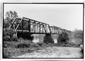 | 5,000 × 3,587 (17.11 MB) | Fæ | GWToolset: Creating mediafile for Fæ. HABS 2014-08-02 (3401:3600) |
File usage
The following pages on the English Wikipedia use this file (pages on other projects are not listed):