

Size of this preview: 800 × 515 pixels. Other resolutions: 320 × 206 pixels | 640 × 412 pixels | 1,024 × 659 pixels | 1,280 × 824 pixels | 2,560 × 1,647 pixels | 10,544 × 6,784 pixels.
Original file (10,544 × 6,784 pixels, file size: 16.71 MB, MIME type: image/jpeg)
| This is a file from the Wikimedia Commons. Information from its description page there is shown below. Commons is a freely licensed media file repository. You can help. |
Summary
| Description |
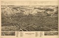
Perspective map not drawn to scale. Bird's-eye view. LC Panoramic maps (2nd ed.), 693 Available also through the Library of Congress Web site as a raster image. Includes col. illus., index to points of interest, and view "West Park." AACR2: 651/1; 710/2 |
||
| Title | Findlay, Ohio, the Gas City. | ||
| Shelf ID | G4084.F5A3 1889 .B8 | ||
| Date | |||
| Source | https://www.loc.gov/item/75694919/ | ||
| Author | Burleigh & Norris; Burleigh Litho | ||
| Permission (Reusing this file) |
|
||
| Other versions |
|
||
| Location | West Park (Hancock County) · Findlay · Hancock County · West Park · United States · Ohio | ||
| Part of | American Memory · Cities And Towns · Catalog · Panoramic Maps · Geography And Map Division | ||
| Subject | West Park, Ohio (Hancock County) · West Park (Hancock County) · Findlay · Aerial Views · United States · Findlay (Ohio) · Ohio |

Licensing
|
This is a faithful photographic reproduction of a two-dimensional, public domain work of art. The work of art itself is in the public domain for the following reason:
The official position taken by the Wikimedia Foundation is that "faithful reproductions of two-dimensional public domain works of art are public domain".
This photographic reproduction is therefore also considered to be in the public domain in the United States. In other jurisdictions, re-use of this content may be restricted; see Reuse of PD-Art photographs for details. | ||||
File history
Click on a date/time to view the file as it appeared at that time.
| Date/Time | Thumbnail | Dimensions | User | Comment | |
|---|---|---|---|---|---|
| current | 21:28, 6 June 2018 | | 10,544 × 6,784 (16.71 MB) | Fæ | LOC Maps https://www.loc.gov/item/75694919/ #6932 |
File usage
The following pages on the English Wikipedia use this file (pages on other projects are not listed):
Global file usage
The following other wikis use this file:
- Usage on arz.wikipedia.org
- Usage on en.wikivoyage.org
- Usage on vo.wikipedia.org
- Usage on www.wikidata.org