

Size of this PNG preview of this SVG file: 494 × 600 pixels. Other resolutions: 198 × 240 pixels | 395 × 480 pixels | 633 × 768 pixels | 843 × 1,024 pixels | 1,687 × 2,048 pixels | 1,108 × 1,345 pixels.
Original file (SVG file, nominally 1,108 × 1,345 pixels, file size: 346 KB)
| This is a file from the Wikimedia Commons. Information from its description page there is shown below. Commons is a freely licensed media file repository. You can help. |
Summary
| Description |
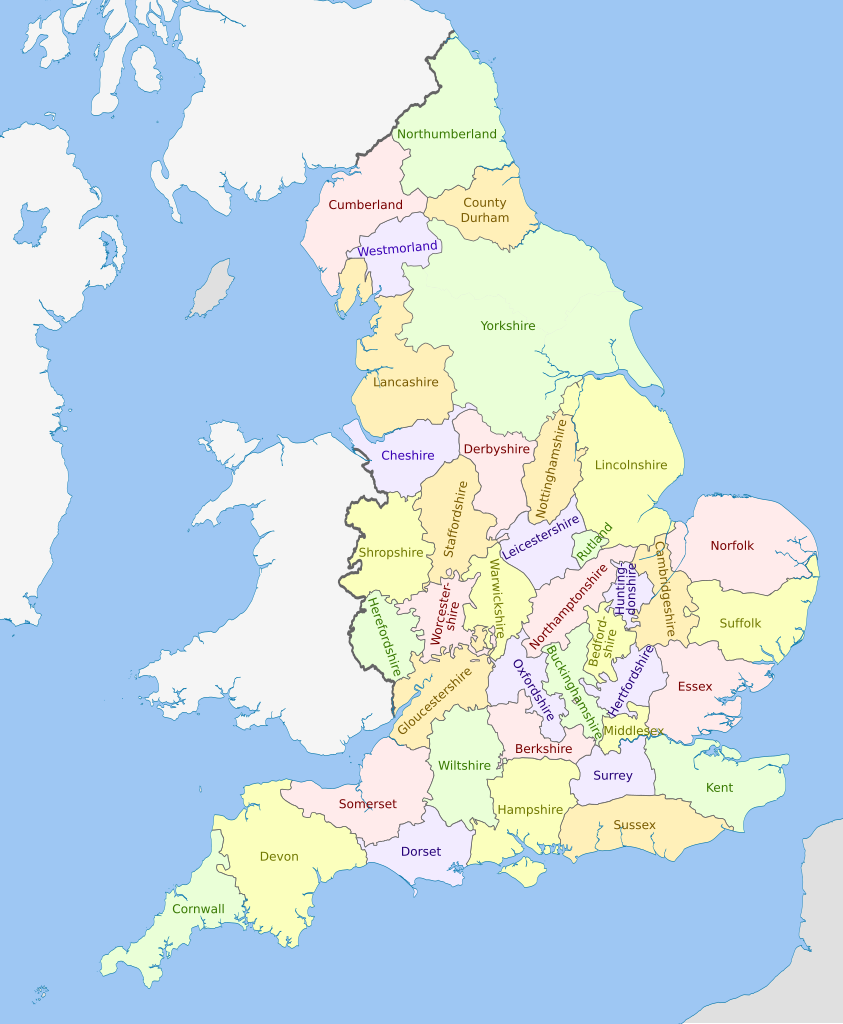
Map showing the historical counties of England in 1851, excluding the City of London. Exclaves and major rivers shown. Counties are named.
Equirectangular map projection on WGS 84 datum, with N/S stretched 170% Geographic limits:
|
| Date | (UTC) |
| Source |
This file was derived from: |
| Author |
|


_svg)
.svg)
Licensing
This file is licensed under the Creative Commons Attribution-Share Alike 3.0 Unported license.
Attribution: Dr Greg
- You are free:
- to share – to copy, distribute and transmit the work
- to remix – to adapt the work
- Under the following conditions:
- attribution – You must give appropriate credit, provide a link to the license, and indicate if changes were made. You may do so in any reasonable manner, but not in any way that suggests the licensor endorses you or your use.
- share alike – If you remix, transform, or build upon the material, you must distribute your contributions under the same or compatible license as the original.
Original upload log
This image is a derivative work of the following images:
- File:England_counties_1851.png licensed with Cc-by-sa-3.0, GFDL
- 2010-07-26T07:03:28Z MRSC 1459x1769 (103262 Bytes) {{Information |Description={{en|1=Counties of England in 1851. Exclaves and major rivers shown.}} |Source={{own}} |Author=[[User:MRSC|MRSC]] |Date=26 July 2010 |Permission= |other_versions= }} [[Category:Maps of England]]
- File:English_ceremonial_counties_2010.svg licensed with Cc-by-sa-3.0, GFDL
- 2010-11-23T16:39:55Z Nilfanion 1108x1345 (308868 Bytes) thicker lines
- 2010-11-23T16:20:19Z Nilfanion 1108x1345 (301520 Bytes) tweaks
- 2010-10-26T20:34:20Z Nilfanion 817x990 (1391832 Bytes) {{Information |Description=Map showing the [[w:ceremonial counties of England]] including the City of London, in 2010. Equirectangular map projection on WGS 84 datum, with N/S stretched 170% Geographic limits: *West: 6.75W
Uploaded with derivativeFX
File history
Click on a date/time to view the file as it appeared at that time.
| Date/Time | Thumbnail | Dimensions | User | Comment | |
|---|---|---|---|---|---|
| current | 14:38, 30 June 2023 | | 1,108 × 1,345 (346 KB) | Dr Greg | spelling correction (Warwickshire) |
| 23:10, 20 March 2012 |  | 1,108 × 1,345 (348 KB) | Dr Greg | correction to status of Ireland in 1851 | |
| 20:43, 19 March 2012 |  | 1,108 × 1,345 (351 KB) | Dr Greg | == {{int:filedesc}} == {{Information |Description={{en|Map showing the historical counties of England in 1851, excluding the City of London. Exclaves and major rivers shown. Counties are named. Equirectangular map pr... |
File usage
The following pages on the English Wikipedia use this file (pages on other projects are not listed):
Global file usage
The following other wikis use this file:
- Usage on de.wikipedia.org
- Usage on pl.wikipedia.org
.svg)